Alert
Alerts
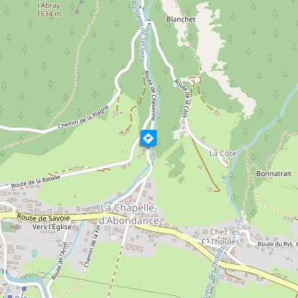
The Abray trail
IGN cards


Description
A walk in the forest starting from the village of La Chapelle d'Abondance with a passage near the deer park and along the stream of Chevenne, ideal for discovering the diversity of trees and mountain flowers with the children.
This easy forest walk starts in the center of the village of La Chapelle d'Abondance, near the little chapel of Notre Dame de la Compassion.
You'll start by climbing the Chevenne road, where you can make a short stop at the fallow deer park.
Then head towards La Plagne for around 800 m to reach a small forest path.
This forest is rich in vegetation, with a wide variety of trees, including spruce, fir, beech, mountain ash, ash and maple...
When you reach a scree slope, the landscape offers magnificent views of Mont de Grange, Châtel and the Dents du Midi.
You'll then reach Chevenne, where the mountain setting of its alpine pastures is superb, with the south face of the Cornettes de Bise, its alpine chalets and stream.
A "snack" break will be most welcome!
You'll also be able to observe many varieties of flowers from different environments, such as the red cephalanther, which lives near scree slopes, or the marsh buttercup, nestling on the banks of streams.
The descent to the village is via a path along the stream. A fitness trail offers stretching and agility exercises. The descent is then via the small asphalt road following the Chevenne stream.
Technical Information
Altimetric profile
Starting point
Steps

Date and time
- From 01/06/2026 to 30/11/2026
Additional information
Open period
From 01/06 to 30/11 daily.
Accessible outside the snow period and depending on weather conditions. Check with the Tourist Office beforehand to find out the current access conditions. Recommended practice period: spring - summer - autumn.
Updated by
Office de Tourisme Leman Mountains Explore - 12/12/2025
leman-mountains-explore.com
Report a problem
Contact
Phone : 04 50 73 51 41
Email : lachapelledabondance@ot-peva.com
Location complements
Access from the tourist office with free parking or shuttle stop 10 m.
Topo guides and map references
Topo guides references :
On sale in the tourist offices of the Abondance valley.
Map references :
Portes du Soleil hiking map in France and Switzerland
TOP 25 N°3528 ET Morzine Massif du Chablais Les Portes du Soleil
Type of land
Stone
Ground
Grit
Not suitable for strollers
Environments
Forest location
Close to a public transportation
Bus stop < 500 m
Near shuttle stop
Village 2 km away
Guidebook with maps/step-by-step
0/ La Chapelle d'Abondance village center - in front of the tourist office.
1/ Take the Chevenne road up past the "Chapelle Notre Dame de la Compassion".
2/ Pass the "parc à daims" and continue up the road.
3/ Turn left at the 3rd junction. Continue towards "La Plagne" for about 800 m.
4/ Take the small path on the right. The path leads to "Chevenne".
5/ Go back down towards the village, following the path along the Chevenne stream, then back on the road to the village.
Animals
Yes. Dogs must be kept on a leash due to the presence of herds and wildlife.
