Lac de la Sassière

Description
A family hike, with no particular difficulty, and a lakeside picnic. A little piece of heaven on earth!
From Saut car park, go back up the various platforms of the car park. Pass the barrier across the vehicle track and follow it to the Sassière dam. Two footbridges are installed from late June to mid-September, to allow pedestrians, pushchairs and accompanied wheelchairs to pass.
Technical Information
Altimetric profile
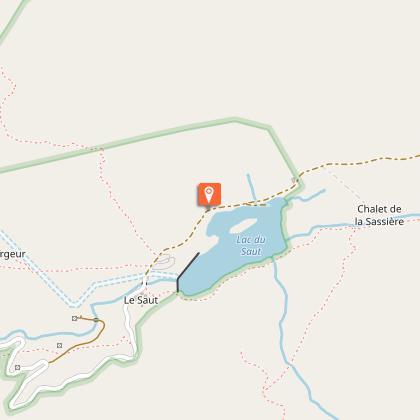
Starting point
Points of interest

Grande Sassière Nature Reserve
Welcome to the Grande Sassière National Nature Reserve. Created in 1973, with a surface area of 2,233 ha, it follows a partial decommissioning of the Tignes-Champagny Nature Reserve to allow the expansion of the Tignes ski area. It is adjacent to the Baillettaz National Nature Reserve. They are both managed by Vanoise National Park. Please respect the regulations to help us preserve the natural heritage.
A glacial rock bar, who has a pickaxe?
Go past the 50 m barrier and turn around. Ÿou will be amazed to see a glacial rock bar of quartzite (polished green-white stones) blocking the valley. In two million years of exertion, the valley’s glacier has eroded the surrounding rocks. As the quartzite is much more resistant and compact than the schist (black in colour), the glacier has polished them, thereby preventing the valley from continuing to collapse. This type of valley is called a “hanging valley”.

Unique rich vegetation
In addition to the herds of chamois and alpine ibex, the nature reserve shelters 32 protected vascular species. For some species, such as the seslenie ovale, the artemisia borealis or the astragalus leontinus, the reserve protects a significant part of the French populations. In terms of protected species listed on the red lists of endangered species, the Grande Sassière Nature Reserve is the richest reserve in metropolitan France. Here, more than elsewhere, you can touch with eyes only even the simplest of sainfoins!

Private pasture
The valley belongs to 3 owners: the municipality of Tignes, EDF and the Milloz family. Since 1987, this family has been farming its own lands and part of the communal lands. The dairy production which comes from 55 tarentaise and abondance cows in the summer grazing period, is transported to the cooperative of Bourg-Saint-Maurice for the manufacture of Beaufort. The Milloz family welcomes you on to its lands. Please stay on the paths and respect the fences.

The wings of the nature reserve
In addition to the small birds in the alpine meadows (the wheatear, the meadow pipit and the Eurasian skylark) the reserve is home to birds of prey including the royal eagle (2.20 m wingspan, brown plumage and round-edged tail) and the bearded vulture (2.80 m wingspan, beige to red body, black wings, light head, black diamond tail). The first comes to hunt marmots, mountain hares, foxes and chamois and ibex kids. The second is strictly a scavenger who mostly eats bones!
“Death and hatred”, you say?
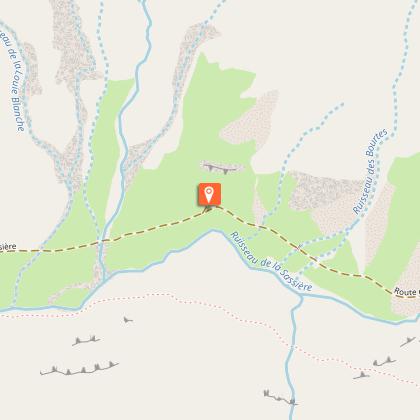
At the Chalet du Santel, make sure you take a look at the stream. Ÿou will be able to see a vegetated mound, in the shape of a crescent moon, pierced by the stream and colonised by numerous marmots. This mound is an old moraine that the glacier, which once occupied the valley, (about– 15,000 years) left during its retreat. The stream firstly had to create a lake which caused this natural dyke.

"“Water, water everywhere!"""
The dammed lake of la Sassière was completed in 1953 in place of a natural lake. It is a “gravity” dam, the mass of materials is opposed to the surge of the water. The rock used for the dyke is quartzite, as at the Verrou du Saut, but it comes from glacial moraines located under the Pointe de la Baillettaz, in front of you. The truck path now serves as a... trail to reach the Col de la Baillettaz.

The surrounding summits
From this perspective, you have a panoramic view of the peaks bordering the nature reserve. To the north, La Grande Sassière (3,747 m in altitude) lustrous schists, from the old French “sassé” meaning “sieved”: rock; to the east: la Tsanteleina, (3,602 m in altitude) with its glacier of Santel; to the south-east, the Pointe de la Baillettaz (2,989 m in altitude), designating a charcoal miner´s hut in the Piedmontese language, but this summit is a mystery; to the south-west: The Aiguille du Dôme (3,017 m in altitude) in quartzite; finally to the west: the Pointe de Picheru (2,953 m in altitude).
Additional information
Advised parking
Parking du Saut, Tignes
Public transport
"
Rail connection to Bourg-Saint-Maurice. Information: www.voyages-sncf.com
Then transport by coach to the administrative centres of Tignes or Val d´Isère. Information:www.transavoie.com
"
Advice
Ÿou can take your dog, but only if kept on a leash. Make sure you take water with you for the day. Ÿou will end at 2,500 m in altitude. Even in summer, you will need to take a windbreaker, jumper and trousers, especially for children.
Accessibility infrastructure
"
Two disabled parking spaces available on the upper platform, two footbridges with access ramps (1 m wide) over the streams of Louie Sabota and Sassière. Activities are carried out specifically for the public in case of physical disability, as well as the loan of an adapted vehicle: www.vanoise-parcnational.fr/fr/accessibilite-et-handicaps/actions-du-parc.html?start=1
"
Access
"
Coming from Bourg-Saint-Maurice on the RD 902, from the Chevril dam follow the direction for “Val d´Isère”. At the exit of the 1st tunnel, follow ""le Franchet"" to the left. Cross the hamlet of Villaret du Nial. After about 1.25 km, at the fork in the road leading to the hamlet of Franchet, take the road that continues to climb. Follow this road to its end where you’ll find a car park with 2 platforms.
"
Arrival
Saut car park, Tignes
Ambiance
Moving from the marmot to the impressive south face of the Aiguille de la Sassière, then to the ethereal flight of the bearded vulture to the graceful alpine bellflower, the whole valley will amaze both young and old alike… inspiring them to return!
Departure
Saut car park, Tignes
Data author
