Alert
Alerts
The tour of the Himalayan Bridges of Monteynard-Avignonet


IGN cards


Description
Hike with the scent of adventure, dizzying sensations in dazzling colors, in the heart of a landscape worthy of the Mediterranean.
Whether you're setting off from Treffort or Mayres-Savel, start your day with a 30-minute guided boat trip to the other side of the river. Then set off at your own pace to return to your starting point via the two footbridges. The Drac bridge is 220 meters long, and the Ebron bridge is 180 meters long. These bridges offer a surprising experience 80 meters above the lake. You'll enjoy an air of the Mediterranean in the heart of the Alps, with the song of the cicadas and the brilliant color of the water.
There are several picnic areas where you can relax and enjoy the panoramic view of the lake. Dry toilets are also available along the way.
FREQUENTLY ASKED QUESTIONS
> Are the Himalayan footbridges at Lac de Monteynard-Avignonet open all year round?
>>> Yes, but beware: in wet weather, the trail can be muddy and slippery. On the other hand, the La Mira boat that makes the crossing only sails when the lake level permits (generally from May 1 to September 31, check with La Mira).
>Are there any charges for crossing the Himalayan footbridges at Lac de Monteynard-Avignonet?
>>>The Himalayan footbridges at Lac de Monteynard-Avignonet are free of charge. Parking charges apply from May to October. Boat crossings are not free.
> Do I have to take the boat to hike the Himalayan footbridges at Lac de Monteynard-Avignonet?
>>> No, the boat allows you to cross the lake to make a loop, which means you can hike both footbridges. If you don't want to take the boat, you can leave from the Treffort lakeside parking lots and walk to the Ebron footbridge, then retrace your steps (round trip).
> Is it possible to book the boat on site?
>>> No. The boat can only be booked online via the mira website reservation.la-mira.com/booking. Places are limited, so please book well in advance.
> How much does the boat trip cost?
>>> Fares 2022: Over 4s: €8 / Reduced fare: €7 / Under 4s: free
> Are dogs allowed on the Lake Monteynard-Avignonet Himalayan footbridge tour?
>>> Yes, dogs are allowed on both the La Mira boat and the Himalayan footbridges at Lac de Monteynard-Avignonet.
>How long does it take to hike around the Himalayan footbridges at Lac de Monteynard-Avignonet?
>>> The Himalayan footbridges tour of Lac de Monteynard-Avignonet takes around 4h30. The hike is 11.9km long and has a vertical drop of 307m.
>Where to park for the Himalayan footbridges tour of Lac de Monteynard-Avignonet?
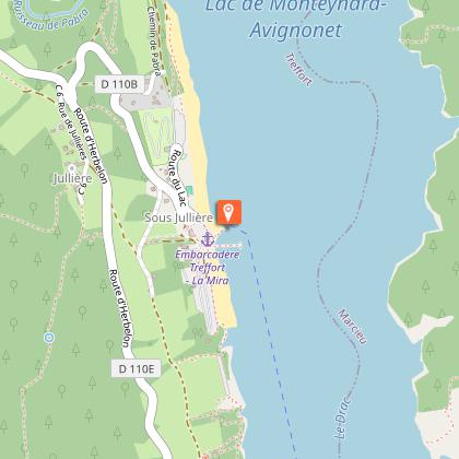
>>> You'll need to park in one of the parking lots near the La Mira boat landing stage on the Treffort side of the lake: parking des Combettes, parking de la plage or parking de La Salette.
If you're making the round trip to the Ebron footbridge, you'll want to use the Vignes parking lot.
> Which way should I hike the Himalayan footbridges at Lac de Monteynard-Avignonet?
>>> We recommend that you start by taking the boat at Treffort to cross the lake to Mayres-Savel. You can then reach the Drac footbridge, continue to the Ebron footbridge and return to your starting point. Starting the hike with the boat crossing allows you to walk at your leisure, with no time constraints during the hike!
> What do I need to bring to hike the Himalayan footbridges at Lac de Monteynard-Avignonet?
>>> To hike the Himalayan footbridges at Lac de Monteynard-Avignonet, you'll need to bring ..:
- water (there's only one watering place at the halfway point)
- walking shoes (no flip-flops)
- sunscreen and hat
- a jacket or sweater (the area can be windy!)
> Is it possible to use a baby carriage on the Himalayan footbridges at Lac de Monteynard-Avignonet?
>>> It is not possible to walk around the footbridges in a stroller, but it is possible to make the round trip to the Ebron footbridge by taking the panoramic trail from the Vignes parking lot on the Treffort side. Please note: you'll need an all-terrain baby carriage (big wheels!) as the track is rocky.
Technical Information
Altimetric profile
Starting point
Points of interest
Date and time
- From 01/10/2024 to 30/04/2025
- From 01/05/2025 to 30/09/2025
- From 01/10/2025 to 30/04/2026
Additional information
Host portrait
An exceptional site between lake and mountain, linked by Himalayan footbridges unique in France.
A moment of escape in the heart of varied landscapes. A hike that's as good for the muscles as it is for the mind...
The 2nd windiest lake in Europe, a must for all water sports enthusiasts.
On weekends in June, July and August, this hike is very busy, making it difficult to fully appreciate this extraordinary experience. We advise you to do this loop at the end of the season.
Sustainable tourism
A must-see site for all nature lovers, thank you for helping us preserve it by respecting waste sorting instructions and good practice.
Guidebook with maps/step-by-step
Departure: We strongly advise you to take the "La Mira" boat from the Treffort pier to the Savel pier. There is a charge for the crossing, so please book well in advance on the La Mira boat website. The crossing of the lake is commented and information on the history of the lake and the footbridges is provided. When you arrive in Savel, the tour begins straight away.
1) From the landing stage, climb slightly and follow the red signposts to the footbridges. Follow the signs, which will take you to a tarmac main road. Drive along the main road (watch out for cars crossing the road). Continue along the sidewalk to find yellow markings. Follow this to the "La Chapelle" sign.
2) From the "La Chapelle" post, follow the signs for the "Passerelle du Drac". Take the small path on the right towards the lake. Pass through the forest and enjoy the fresh air and views of the turquoise lake. At the "Le pont" post, continue towards the "Passerelle du Drac". You will then come to the "La tourbe" post.
3) From the "La tourbe" post, follow the signs for the "Passerelle du Drac", which is only 800 m from your position. You can even see it from the path you're on. You arrive at the footbridge. There's a magnificent view of the lake and the Drac river. Take the time to take a few photos, then walk the 220 metres to find a second post.
4) From the second "Passerelle du Drac" post, follow the signs for "Ruisseau des Lavanches". A good stretch of forest awaits you, with a steep climb to the stream, where you'll need to take a break. From the stream, follow the signs for "Les Horts". You'll come to a larger track, which you should take until you reach a tarmac road. Continue uphill as far as "La Pravière", keep going and you'll come to the "Serre de Lavana" post, where you finish the climb.
5) From "Serre de Lavana" you are at the top of the hike. Take the tarmac road southwards, then take a small path down to the right. There's a long, pleasant descent through the forest. The trees reveal some lovely views of the lake, so keep your eyes peeled. Picnic tables are also available. Just before you reach the Ebron footbridge, you'll have a view of the Pont de Brion (bridge dating from 1951). Proceed with caution, as the path to the footbridge is narrow and there is a risk of falling if you cross.
6) You arrive at the Ebron footbridge, which is smaller than the Drac footbridge. It is no less impressive. Make the 180-metre crossing to reach the picnic area opposite. Here, you can rest for a while. Next, you'll come to the "Passerelle de l'Ebron" post, where you'll follow the signs for "Embarcadère la Mira par le sentier forestier". This pleasant path will keep you cool and close to the lakeside. Follow the narrow path to the "Les Sagnes" post.
7) From "Les Sagnes" follow the signs for "Baraton Bas". A new path in the forest opens up. After this path you'll come to the first parking lot (Les Vignes), which you'll cross until you reach the road where you'll find the "Herbelon" sign.
8) From "Herbelon", a main road leads over the campsite. Be careful to keep to the side of the road, as there are frequent car traffic. At the bend, turn right onto a gravel path, then right again onto a small forest track. This leads to a new parking lot, which you'll have to cross. The Embarcadère de la Mira is now in front of you!
Environments
Lakeside or by stretch of water
Updated by
Office de Tourisme du Trièves - 15/10/2024
www.trieves-vercors.fr
Report a problem
Open period
From 01/05 to 30/09, daily.
From 01/10 to 30/04, daily.
Location complements
Access Treffort from Grenoble RN1075 or A51 freeway, exit 13, then follow signs for Sinard, Treffort, le lac.
Access Mayres-Savel from Grenoble, Route Napoléon, Vizille, Laffrey, La Mure, then D116, to Savel beach.
Tricky passages
The walkways are suspended above the void! If you're prone to vertigo, they may not be advisable.
When it rains, the path becomes very muddy!
Type of land
Ground
Grit
Not suitable for strollers
Contact
Phone :
04 82 62 63 50
0476341448
Email : contact@trieves-vercors.fr
Website : www.trieves-vercors.fr
Reception complements
Be well-shod (no flip-flops!) and bring plenty of water.
Adapt your equipment to your level and the weather.
Stay on the marked trails.


