Alert
Alerts
Hiking loop : balcon des Crêts


IGN cards


Description
Easy walk on a landscaped path through vast alpine plains. Enjoy exceptional views of Mont Blanc, Annecy lake, the valleys of Arve and Giffre, the town of Geneva and Lake Geneva.
An easy family walk, the Balcon des Crêts hike takes you up and down the Salève mountain in a remarkable area of flora and fauna.
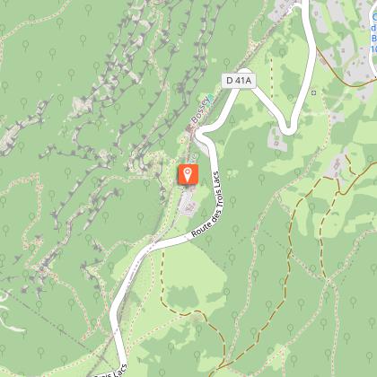
Departing from the "De La Bouillette" parking lot, you'll set off on a loop of just over 5km to discover the mountain pastures and panoramic views of Lake Geneva and Annecy, as well as the snow-capped peaks of the Alps.
Close to the paragliding launch site, take the opportunity to admire the spectacle of the pilots as they take off.
Near your departure point, you can quench your thirst with a cool drink from the Café des Crêts.
Technical Information
Altimetric profile
Starting point
Additional information
Open period
All year round daily.
Please check with the Tourist Office beforehand for current access conditions.
Subject to favorable snow and weather conditions.
Tips
Along the way, discover a view of Geneva and Mont Blanc, the Grange-Gaby chalet and pond, a granite boulder, and a paraglider and scale-model take-off area.
Updated by
Conseil Départemental de la Haute-Savoie - 20/11/2025
www.hautesavoiexperience.fr
Report a problem
Environments
Panoramic view
Lake view
Mountain location
Contact
Phone : 04 50 04 71 63
Website :
https://www.montsdegeneve.com
https://www.montsdegeneve.com/a-voir-a-faire/pedestre/les-itineraires-pedestres/
Type of land
Rock
Ground
Location complements
Access by car: From Annemasse, head for Monnetier-Mornex, then the Salève cable car. At the Salève cable car, continue straight ahead. You will pass the restaurant L'Observatoire and continue straight on the Route des Rochers de Faverges until you reach the intersection with the Chemin des Crêts, where you will find the roadside car park on your left.
Topo guides and map references
Map references :
TOP 25 IGN 3430 OT - MONT-SALÈVE / SAINT-JULIEN-EN-GENEVOIS / ANNEMASSE
Reception complements
Whatever your hike, remember to pack cereal bars, plenty of water, sunglasses, sunscreen, a small first-aid kit, and clothing appropriate to the season and weather forecast.
Guidebook with maps/step-by-step
1/ From the ‘La Bouillette’ car park, head towards ‘Alpages des Crêts’.
2/ From the ‘Alpage des Crêts’ signpost, continue towards ‘Sur le Charrot’.
3/ From ‘Sur le Charrot’ continue towards ‘Sur la grande Gorge’.
4/ From ‘Sur la grande Gorge’, follow the signs for ‘La Bouillette par Grange Gaby’. You will pass the following signposts: ‘Grange Gaby’, ‘La Pile’ and ‘Sous les Crêts’ before arriving at ‘La Bouillette’, your starting point.
Animals
Yes. Dogs must be kept on a leash in the presence of herds.
Data author
