Alert
Alerts
Centre VTT-FFC de l'Albanais - Circuit n°10 'Entre Monts et Etangs'

IGN cards


Description
Explore protected plants and wildlife along this ride around the Etangs de Crosagny.
In front of the train station, head west to join the RD 1201 towards Saint Germain La Chambotte. When you reach the playground, turn right onto the 'rue de Savoie', then continue along the 'route de Pouilly'.
Continue along this road, then turn right onto a path across fields. When you reach the hamlet of Futenex, continue along the 'route de Cessens' before turning onto the 'chemin des Crochets'.
On your right, go around the farm, crossing fields to rejoin the hamlet of 'les Granges'. At the junction, continue straight on along the 'chemin des Granges', which will pass through the forest for a significant stretch.
After a short distance above the hamlet of 'Collonges', take a wooded path towards the north, until you reach the hamlet of 'les Crouteaux'. Turn onto the 'chemin des Crouteaux' until you reach the source of the Combe, then continue west along a path through the fields. At the junction with the Circuit Noir n°11, turn right towards the hamlet of 'Montdurand', then turn right along a farm to rejoin the path between Saint German La Chambotte and Cessens.
At the intersection with the Circuit Noir n°11, turn right onto an uphill path through the woods, until you rejoin the source of the Combe. Next, turn left along a path until you reach the hamlet of Dressy and the junction with the RD 54. Turn right towards the hamlet of 'Ansigny', then, once you reach the bread oven, turn left onto a path through fields until you reach the hamlet of 'Mazet'.
After a short distance, take the 'chemin de Ballentrand' towards Bloye.
At the junction with the RD 910, continue straight on along the 'route du Petit Salagine', then cross the railway to reach the 'chemin des Etangs'.
Continue along this path until you reach the Etangs de Crosagny, then head towards the Moulin de Crosagny.
At the windmill; turn right onto a path through fields until you reach the 'route de Braille'. Take the wooded path opposite until you reach the Stade Sportif de Saint Félix and continue towards the centre of the village.
At the crossroads with the RD 1201, turn right before turning onto the 'rue de Saint Girod'. Cross the motorway and turn left after the bridge.
Next, turn right along a wooded path towards Saint Girod and the hamlet of 'Chamberaz'. Once you reach the hamlet, follow signs towards Chainaz-les-Frasses, then take another path until you reach the hamlet of 'Les Lansards'.
Once you reach the hamlet, turn right towards the administrative centre of Saint Girod, then take the final road on the left as you leave.
Next, continue through fields to reach the administrative centre of Saint Girod. In front of the Town Hall, head south towards Aix-les-Bains, then turn right onto a path as you leave the hamlet. Continue along this path until you reach the motorway underpass, then head north towards 'La Deysse'.
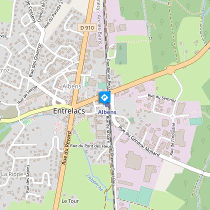
Cross the river, then, at the intersection with the 'route d'Orly', cross the railway to take the 'chemin Sous-Bois' to return to the Albens train station.
Technical Information
Altimetric profile
Starting point
Additional information
Updated by
Agence Aix-les-Bains Riviera des Alpes - 24/06/2024
www.aixlesbains-rivieradesalpes.com
Report a problem
Open period
All year round between 8 am and 5 pm.
Subject to favorable weather.
Contact
Phone : 04 79 63 06 99
Email : info@cc-cantonalbens.fr
Website : www.cc-cantonalbens.fr

