Alert
Alerts
Type of practice
Walking
Medium


Presentation
Description
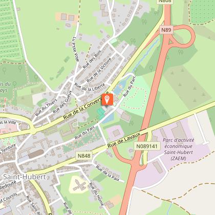
Map
Points of interest
Ratings and reviews
See around
Chenêt


Credit : ©MTFSH TEXTO Pascal Willems
IGN cards

105 CHARLEVILLE-MÉZIÈRES VERDUN FÔRET DES ARDENNES VALLÉE DE LA MEUSE
Editor : IGN
Collection : TOP 100
Scale : 1:100 000
8.40€

D02-08 AISNE ARDENNES
Editor : IGN
Collection : CARTES DÉPARTEMENTALES IGN
Scale : 1:150 000
5.90€

NR04 - GRAND EST RECTO/VERSO ARDENNE CHAMPAGNE
Editor : IGN
Collection : CARTES RÉGIONALES IGN
Scale : 1:250 000
6.80€

NR05 GRAND EST RECTO/VERSO MASSIF DES VOSGES ALSACE LORRAINE
Editor : IGN
Collection : CARTES RÉGIONALES IGN
Scale : 1:250 000
6.80€

ALLEMAGNE
Editor : IGN
Collection : DÉCOUVERTE DES PAYS DU MONDE IGN
Scale : 1:800 000
7.00€

EUROPE
Editor : IGN
Collection : DÉCOUVERTE DES PAYS DU MONDE IGN
Scale : 1:2 500 000
7.00€

PAYS-BAS BELGIQUE LUXEMBOURG
Editor : IGN
Collection : DÉCOUVERTE DES PAYS DU MONDE IGN
Scale : 1:300 000
7.00€
Description
During this walk, you can discover the town and some of its sights (Saint-Roch chapel, Redouté Museum, the Chenet, pottery, etc.) It will take you through the undergrowth to the village of Vesqueville.
This signposted walk can be found on the Saint-Hubert walking map, available for 8€ at the Maison du Tourisme de la Forêt de Saint-Hubert.
Beacon: red lozenge
Technical Information
Walking
Difficulty
Medium
Dist.
8.7 km
Type of practice
Walking
Medium
Show more
Altimetric profile
Starting point
Rue du Parc
,
6870
Saint-Hubert
Lat : 50.02873Lng : 5.38156
Points of interest


Additional information
Signalétique (EN)
Pedestrian - Diamond - Red
Data author

proposed by
Maison du Tourisme de la Forêt de Saint-Hubert
15 Place du Marché 6870 Saint-Hubert Belgique
Ratings and reviews
To see around