Alert
Alerts
Hiking trail : the Mont d'Arbois - Mont Joux

IGN cards


Description
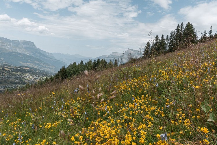
Along the path admire one of the last farms in the middle of the meadows of alpine flowers, gentians, primroses, cows-lips, buttercups, etc... and the panoramic view over the golf course. Uninterrupted view of the Mont-Blanc massif.
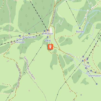
From the Mont d'Arbois gondola, on foot, continue on the road towards the village of Planellet. Follow the signs «Mont d'Arbois» by the variant of the Tour du Mont Blanc (yellow and red).
From the upper station of the Gondola take the path that runs along the restaurant "Idéal 1850". Follow the crest line that passes close to the Bettex Gondola rises in the direction of Mont Joux. Exceptional views of the Mont Blanc, the Aravis, the Val d'Arly and the Arve Valley.
From Mont Joux (1958 m), head down to the chalets of Joux then Lac de Joux follow direction Megève, enter the forest until the Alpages de Tornay high (1620), continue on a path until the Hameau du Planellet.
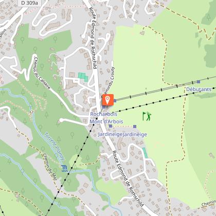
From this hamlet you can reach the Mont d'Arbois gondola by the Edmond de Rothschild road (about 10 minutes).
Technical Information
Altimetric profile
Starting point
Points of interest
Date and time
- From 01/05/2026 to 30/11/2026
Additional information
Open period
From 01/05 to 30/11.
Subject to favorable weather.
Updated by
Mairie de Megève - 13/06/2025
mairie.megeve.fr
Report a problem
Contact
Phone :
04 50 21 27 28
04 50 21 27 28
Email :
megeve@megeve.com
megeve@megeve.com
Website :
https://www.megeve-tourisme.fr/
https://www.megeve-tourisme.fr/
https://megeve-booking.com
Facebook :
https://www.facebook.com/mairiemegeve
https://fr-fr.facebook.com/megeve/
https://www.facebook.com/megeve
Location complements
Parking available at the Mont d'Arbois gondola parking lot. In season, shuttle bus stops in front of the gondola. Possibility of taking the gondola up to Mont D'Arbois during the summer season.
Topo guides and map references
Map references :
Mont Blanc Belvedere map recommended.
Type of land
Ground
Not suitable for strollers
Environments
Mountain location
Guidebook with maps/step-by-step
0/ From the Mont d'Arbois Télécabine, continue on foot towards the village of Le Planellet.
1/ Follow the "Mont d'Arbois" signs for the Tour du Mont Blanc variant (yellow and red).
2/ From the top station of the Télécabine, take the path alongside the "Idéal 1850" restaurant.
3/ Follow the ridge line which passes close to the Télécabine du Bettex and rises towards Mont Joux. Exceptional views of Mont Blanc, Les Aravis, Val d'Arly and Vallée de l'Arve.
4/ From Mont Joux (1958 m), head downhill towards the Chalets de Joux and then Lac de Joux.
5/ Follow the signs for Megève, entering the forest as far as the Alpages de Tornay haut (1620).
6/ Follow a path to the Hameau du Planellet.
7/ From this hamlet, walk to the Mont d'Arbois Télécabine via the Edmond de Rothschild carriage road (approx. 10 minutes).
Animals
Yes. Dogs must be kept on a leach.
Data author
