Alert
Alerts
The Mortes and Bellefontaine Lakes


IGN cards


Description
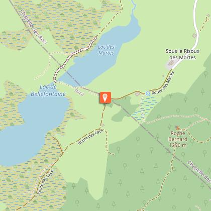
From the viewpoints on Roche Champion and Roche Bernard, the striking Nordic nature of the High Jura's lakes, peat bogs and mountain forests grabs hikers' attention.
From the village's small central square, at the hike's starting point, the trail follows the D 46 towards the town hall (white and red waymarking). At "chemin des Sources", a road to the left crosses the combe, borders a peat bog and ascends to La Madone.
The path skews off to the left crossing a wooded meadow. At the Reservoir, the trail ascends to the right through a pasture and leads to LA ROCHE CHAMPION. Occasionally rocky, this path continues between the rocky barrier and the swiss border, heads past the Git de l’Echelle and on a wider path, leads to Sur-le-Risoux-des-Lacs, and, turning right, to the Rocky Crossroads.
The unmissable belvedere of Roche Bernard can be accessed to the left within 5 mins.
From the Rocky Crossroads, a stony forest road, "heads down the hill" (yellow and red waymarking) before leading to the Customs Barrack.
Follow the road to the left (white and red waymarking). Head past the ON THE LAKES viewpoint and continue on a white path that overlooks the peat bogs through La Feuillat until you reach les Grands Pins.
The trail then follows the D 18 to the right (yellow waymarking) and at the first crossing (the Chalet of Mandrillons) takes a left turn onto the road towards Chaux Mourant before reaching les Assignats.
To the right a forest path interspersed with clearings leads to the Chez Bourgeois and Chez Jean Bouveret hamlets. Continuing in the same direction, the trail which is mostly a forest path opens onto the D18 at LES MORTES. Follow the road to the left and take the little road to the les Mortes hamlet (yellow and blue waymarking) to reach Les Mortes Little Woods Crossroads to the left via the D46.
The trail takes the D 46 E to the left and leads a crossroads with "chemin des Bornes". A path heads uphill to the right, enters the forest and descends to La Toumire and later La Chaumeau.
The path the heads back uphill to the right along the edge of the la Chaumeau pasture, branches off to the left along a trail through the meadows towards to the road to les Chaumelles.
Cross the road and, on the other side, a combe and a wooded meadow that lead to les Champs Nouveaux.
Take the road to LES LANDRY to your right (white and red waymarking), and then a road west of the village to return to CHAPELLE-DES-BOIS.
Technical Information
Altimetric profile
Starting point
Points of interest
Additional information
Public transport
To visit and get about in the High-Jura, visit www.reshaut-jura.fr, the eco-mobility portal listing all means of transport within the Park.
Advice
Be careful on the steep slopes and cliff edges between Roche Champion and Git de l’Echelle. This trail passes through pastures with livestock and forest paths. To respect the owners and farmers granting you passage, and for the security of livestock and wild fauna, we ask that you remain on the waymarked paths.Use the adapted passageways to get across fencing and be sure to close gateways behind you. Please keep your dog on a lead if you have one.Wild flowers are beautiful, they may be rare and protected and often wilt quickly. Do not pick them! They will delight the next hikers.In case of forest works (felling, skidding, etc.), for your safety, know when to stop and turn around.
Advised parking
in front of the church, start map
Access
16 km south of Mouthe via the D 437 followed by the D 46, and 15 km from Morez via the N 5, followed by the D 18 through Bellefontaine and lastly the D 46.
Arrival
Church parking lot, Chapelle-des-Bois
Ambiance
"20,000 years ago, the glacier would crash against the Roche Champion cliff, before giving way to a lake. Later, climate change would foster an abundant amount of aquatic vegetation, the slow decay of which filled the depressions of the black peat." Marc Forestier, (Dakota Edition, Que faire dans le Parc naturel régional du Haut-Jura - What to do in the natural regional park of the High-Jura)
Departure
Church parking lot, Chapelle-des-Bois


