Alert
Alerts
Curiosities circuit

IGN cards





Description
Curiosity: what catches the attention, the interest. The many sites and monuments that mark out this pleasant hike best meet this definition.
They are from all periods, from the Neolithic to the Middle Ages, and from the Renaissance to the 19th century. You will thus discover them in the town of Château-Landon as in its nearby countryside.
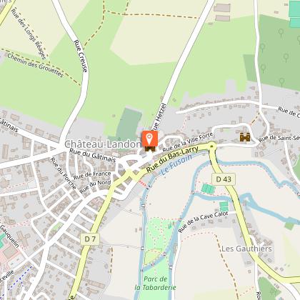
1 - With your back to the Tourist Office, go left and turn left twice to follow rue Moïse. Take the rue de la Ville Forte on the left (north postern). At the level of the old St Séverin Abbey, climb the path (staircase) to the left then the road to the left, leaving the streets to the right and to the left. Go up the Chemin des Carrières to the right. Keep the same direction and go behind the sports fields. Walk along the wood then leave it.
2 - Turn right, follow the road to the left towards Mocpoix. 50 m after the water tower, take the path on the right to bypass the hamlet. At the cross continue straight, cross the street and take the Chemin des Grattiers opposite. Walk along the wood for 1500 m, enter the Bois de Montuffé [on the right, the polissoirs site (A)] and descend to the right towards the Loing canal.
3 - After the pumping station, turn right along the canal. Go past the canal bridge (B). Leave the canal to follow the path to the right which crosses a stream. Turn right into the lane and left into the next one which crosses the Concorde and leads to Château-Landon. 150m to the left of the entrance to Pont Franc, access to the Pontfrault bridge (C) and, to the right of the hamlet, view of the old abbey-leper colony (D). Continue on the road, walk alongside the mill of Gillier then take the rue de St Séverin on the left. Pass at the foot of the old Abbey, turn left onto the D43. Take the Amoureux's path to the right.
4 - Walk along "le Fusain", pass the large communal wash house and enter the Tabarderie park. Leave the bridge on the right then cross the next one. Go up the path and turn right onto Chemin de la Haie de Banse.
5 - Follow the street on the left (ruined tower on the right), rue du Général de Gaulle on the right (Tour St André) then rue St André on the left. Turn right on rue Jallemain, go straight ahead and cross place St André. Turn left onto Boulevard Carnot then the street to the right and the second to the left. Make a left-right and take the rue de France then turn in the second street to the right rue Thiers. Turn twice to the left to come out on rue du Gâtinais. Follow it to the right then take rue Galland on the left to the Place du Marché and the Tourist Office.
This route is marked in blue by the Codérando.
Technical Information
Altimetric profile
Starting point
Points of interest
Additional information
Environments
Riverside
Town location
Close to a public transportation
Village centre
Close to GR footpath
Waterside
In the historic centre
Panoramic view
Updated by
Office de Tourisme Gâtinais-Val de Loing - 12/06/2025
www.tourisme-gatinaisvaldeloing.fr
Report a problem
Open period
All year round.
Contact
Phone : 01 64 29 38 08
Email : tourisme@ccgvl77.fr
Website : www.tourisme-gatinaisvaldeloing.fr/activites/circuits-pedestres-et-velos/circuits-pedestres/?mb_page=circuit&mb_id=61019&mb_titre=circuit-des-curiosites&mbscrollto=module
Facebook : www.facebook.com/officedetourismegatinaisvaldeloing/
Type of land
Stone
Ground
Hard coating (tar, cement, flooring)
Data author

The Cirkwi brief
Nestled in the heart of France, Château-Landon offers an itinerary designed by the local Office de Tourisme that promises a journey through time. This trek, appealing to the curious and the adventurous, unveils the rich tapestry of history and nature combined. From Neolithic sites to medieval wonders and Renaissance splendor, each step introduces the traveler to stories etched in stone and landscapes. With diversity spanning centuries, this route doesn't just guide your feet; it transports your imagination, offering a palpable sense of the past amidst the tranquility of the countryside. Let's not just walk; let's wander with purpose through Château-Landon's historic marvels.
Technical Route Overview
Spanning 14 kilometers, the journey initiates from the Office de Tourisme in Château-Landon, weaving through urban streets before merging with rural paths. The route negotiates a series of ascents and descents, peaking at an altitude of 109 meters, and touches its nadir at 67 meters. The total elevation gained is a noteworthy 358 meters, marking a moderate challenge. Key waypoints include the majestic ruins, serene canals, and verdant forestry, with the path meticulously marked in blue by Codérando. This technical amalgamation of urban and rural terrains necessitates both vigor and vigilance.
Seasonal Guide and Safety Tips
Traversing Château-Landon's landscape can vary dramatically with the seasons. Spring and autumn afford temperate weather, making them ideal for this adventure. During these seasons, the path's beauty is enhanced with blooming flora or the rustic colors of fall, respectively. Summer offers longer daylight hours, yet preparation for warmer conditions is essential. Conversely, winter requires caution due to slippery paths and shorter days. Regardless of the season, appropriate footwear is crucial, as certain segments demand good grip. Also, staying hydrated and carrying a map or GPS device enhances both safety and enjoyment.
The Heart of Gâtinais Val-de-Loing
Château-Landon, deeply ingrained in the fabric of the Gâtinais Val-de-Loing, stands as a testament to the region's vibrant history and cultural significance. Once a powerful medieval fortress, this area has witnessed the ebb and flow of French civilization, from ancient settlers to lords of the Renaissance. Its architecture, from the ruins of fortifications to the serene abbey, narrates stories spanning centuries, while its natural landscapes bespeak the area's geological history. Château-Landon is not just a locality within the Île-de-France region; it's a gateway to understanding the diverse cultural and historical heritage that France proudly showcases.
Climate Insights and Best Visit Time
Château-Landon, nestled within the Île-de-France region, enjoys a temperate climate. Spring (March to May) reveals a fresh, verdant landscape, perfect for exploring. Summer months (June to August) are warm, providing ample daylight for longer treks, though can be humid. Autumn (September to November) brings cooler temperatures and a cascade of colors, while winters (December to February) are mild but can be wet, making some paths slippery. For an optimal experience, plan visits between late spring and early autumn, when the weather balances comfort with the beauty of changing seasons.
