The mines of Challanches - Hiking

Description
This hike gives you panoramic views over the lower part of the Eau d'Olle valley and Bourg d'Oisans.
TECHNICAL INFORMATIONS
Starting point: Parking of the hamlet "La Traverse" (Allemond)
Elevation gain: 636 m
Distance: 2,9 km
Time : 2h (climb), 1h35 (downhill)
Level: Easy
MAP
IGN TOP 25 n°3335 EST
OBP n°2 (Oisans au Bout des Pieds) : trail 210
ROUTE
From the hairpin bend after La Traverse, continue 500m, the path starts uphill on the left. It begins in the forest then opens out over a series of small valley wich may be difficult depending on the previous winter conditions.
A different descent is possible by 210 bis (1h55 return route).
CULTURE
The Chalanches mines, wich were exploited during Louix XVI's reign, were rich in different minerals, but difficult to eploit in such high mountains.
Technical Information
Altimetric profile
Starting point
Steps
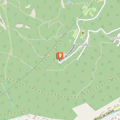
Départ/Arrivée : Parking du hameau de la Traverse (Allemont)
Du virage en épingle au dessus de la Traverse, continuer la route sur 500 mètres environ.De la, le sentier démarre à sa gauche en montant. Il commence par traverser la forêt, puis en sort pour continuer plein ouest et passe une série de combes qui peuvent s’avérer délicates en fonction des vicissitudes
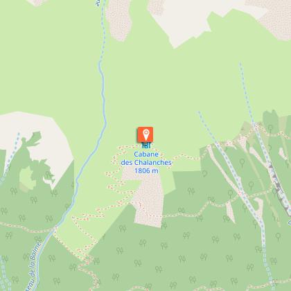
Cabane de Challanches
Vous êtes arrivé au sommet de l'itinéraire, BRAVO !Arrivée à la cabane, redescendez par un autre chemin qui continue tout droit et vous fait arriver directement à votre voiture.
Date and time
- From 01/05/2024 to 31/10/2024
- From 01/05/2025 to 31/10/2025
Additional information
Environments
Mountain location
Updated by
Oisans Tourisme - 24/06/2024
www.oisans.com
Report a problem
Open period
From 01/05 to 31/10.
Subject to favorable snow and weather conditions.
Contact
Phone : 04 76 80 71 60
Email : info-allemond@oisans.com
Website : www.oisans.com/stations-et-villages/allemond/
Location complements
In Allemond follow towards "Allemond Eglise". Turn on the left just before the cucrh, towards "La Traverse". After "La Traverse" hamlet park your car in the next turn. The path begins a little higher on the left (following the road).
Data author
