Refuge des Clots - hike


Description
A lavender-scented balcony path rising above the Lac du Chambon takes you to the small mountain hut of Les Clôts. Don't miss the Lac Lovitel theme trail!
If walking with young children, you'll need to hold their hands tightly along the balcony path, with its exposed views. The hike starts off in a very arid landscape, before climbing up to the Lovitel oasis.
TECHNICAL INFORMATION
Starting point: Parking des Aymes
Height gain: 270 m
Total duration: 2 1/2 hours
Distance: 7 km
Level: Easy
MAP
OBP no.3 (Oisans au Bout des Pieds): path no. 363-GR50
DURING THE HIKE
- The panoramic view over the Chambon lake
- The Lovitel lake discovery trail
- A viewing table
- The eco-museum
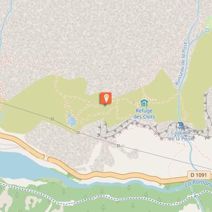
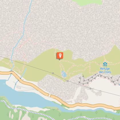
-The Refuge des Clots small mountain hut
Technical Information
Altimetric profile
Starting point
Steps
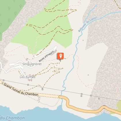
Hameau des Aymes
Suivre le sentier (GR 50) en balcon jusqu'au refuge des Clots.
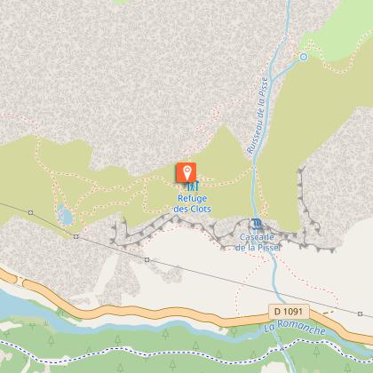
Refuge des Clots
Le mot du gardien : "Juste à côté du refuge, une cabane est aménagée en écomusée : sa visite complétera votre passage par le sentier de découverte, et vous rendra incollable sur la faune, la flore et la vie dans les alpages d'Emparis. Depuis la route nationale, observez l'immense cascade de la Pisse : le refuge est situé immédiatement au dessus !
Sentier de découverte du lac Lovitel
Faite le détour par le lac Lovitel au retour par le sentier à gauche.
Retour au parking
Retrouver le sentier du GR 50 pour le chemin du retour.
Points of interest

Refuge Les Clôts
A lovely mountain hut near Mizoën at an altitude of 1515 m. A stopover on the GR50 54C tour of the Ecrins and the start of numerous hikes on the Emparis plateau. Close to the petrifying Cascade de la Pisse waterfall, the via ferrata and a climbing route. Superb views of the Meije.From the car park at Les Aymes, follow the path marked in red and white (variant of the GR 54 path): the balcony trail makes its way above the Lac du Chambon before climbing up across the meadows. From there, hikers can either follow the discovery trail to the right that joins the refuge (adding ½ hour) or carry straight on to Les Clots. The walk and hut have been awarded the "Espit Parc" label and are perfect for families and people looking for peace and quiet and to reconnect with their inner selves! Along the way, and near the refuge, depending on the time of your visit, you may see marmots, chamois and butterflies, and depending on the season, feast your eyes and nose with lavender and orange lilies. You’ll also have a chance to admire the waterfalls above the hut, gushing out of a petrified fountain, forming lumps of tuf. The site is under a biotope protection order, so please stay on the path to avoid damaging this geological wonder.

The Ferrand round trip (Circuit n°14)
The Ferrand valley is the least developed of the six Oisans valleys. Indeed, the name Ferrand comes from the Latin “ferus”, meaning “wild”, to portray the raging mountain river that flows through this beautiful, secret and little-visited area.This almost 64 km circuit start in Bourg d'Oisans. The villages of Ferrand' valley have cleverly managed not to give in to modernisation and have gracefully travelled through the ages. With its jumble of buildings, thick stone walls and roofs that seem to almost tough each other, Besse-en-Oisans is one of the prettiest villages in Oisans, if not in the French Alps. Indeed, it has been classed by the French Building Association. In local patois dialect, “bes” is the word for birch, since, until it was totally destroyed in a fire, a birch forest used to caress the village with its silver branches. Located in the heart of the village, the ↘Maison Départementale des Alpages (Mountain Pasture Centre) admirably portrays the soul of the surrounding mountains and region. Run by real enthusiasts, this centre retraces the history of the area as shaped by man throughout the ages, with a fun and educative approach to a world that is kept very much alive through exhibitions, films and old objects. You then drive on towards Clavans-en-Haut-Oisans, before tackling the narrow road up to the Col de Sarenne, (closed in winter). Once over the Sarenne mountain pass, wind your way down into the Sarenne valley which leads to Alpe d’Huez resort. Discover the↘archaeological site of Brandes, just before the altiport (on left of the road). An exhibition presents this unique site in Europe at ↘Huez and Oisans Museum. Stop off for a visit to the resort before returning to Bourg-d'Oisans.
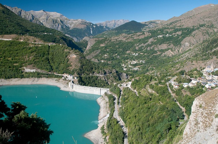
Barrage du Chambon
The Chambon dam was built between 1929 and 1935. In 1918, the industrialist Henri Frédet discovered the potential of this narrow, 75m long section of the Romanche river. It proved to be the ideal location for regulating the flow of the river.In 1921, studies showed that the presence of hard, cristallin schist in the soil provided a perfect seal for the water. The potential of hydroelectricity drew the attention of speculators during the 1920s stock exchange boom. Despite having to flood the villages of Le Chambon,Le Dauphine and Pariset, work began on the dam. During the construction period, a temporary cable car was set up over a 10.5 km stretch from Bourg d'Oisans to Le Chambon to supply the site with cement and other materials more rapidly. This cable car had 193 huge buckets that could each carry 250 km of cement. 62 metal pylons were built 900 m apart, some up to 40 m high, to bear the weight of the 22.5 km steel cable. The reservoir filled with water between 24 April and 9 October 1935. As early as May 1935, the turbines of the Sainte-Guilherme power plant were being driven by water and intake from the neighbouring Ferrand Valley was later added to boost the supply of water.

Natura 2000 : la Fontaine Pétrifiante
Située à 1 750 mètres, dans la commune de Mizoën, la Fontaine Pétrifiante est une cascade naturelle fascinante. Visible depuis le GR54C, cette résurgence compte parmi les plus belles de France et doit son origine à la nature géologique du site.La fontaine pétrifiante, qu’est-ce que c’est ? Depuis 190 000 millions d’années, la formation de cette résurgence est la conséquence d’une faille séparant deux ensembles de roches aux caractéristiques physiques très différentes. Voici comment ! Les eaux qui jaillissent de cette cascade proviennent du Plateau d'Emparis, situé à 2 372 mètres d’altitude. C’est donc plus haut que les eaux s'infiltrent à travers des couches de roches sédimentaires perméables, riches en calcaire soluble, et se chargent en bicarbonate de calcium. Sur leur chemin, elles rencontrent un nouveau type de roche. Il s’agit d’un sous-sol hercynien, composé de roches cristallines imperméables. Les eaux ainsi bloquées sont contraintes de suivre l'axe de la faille pour resurgir à la surface. À ce moment-là, l'eau entre en contact avec l’air produisant ainsi une réaction chimique. Le résultat crée une roche sédimentaire tendre, appelée tuf calcaire. Ce tuf, de couleur jaunâtre tirant sur l’orange, s'accumule en couches successives au fil du temps. Souvent, cette roche capture des fragments de végétaux. Lorsque ceux-ci se décomposent, ils laissent derrière eux des cavités qui forment des tubes creux et des alvéoles à l'aspect caverneux caractéristiques du tuf. Ainsi, l'empreinte de ces végétaux peut être conservée pendant des millions d'années. La Fontaine Pétrifiante n’est donc pas qu’une simple cascade, mais aussi une tufière. Pour information : autrefois, le tuf calcaire était employé comme matériel de construction pour les maisons des villages aux alentours. Facilement sculptable due à sa porosité, sa légèreté et sa résistance, il était surtout utilisé pour les pièces d’ornement (encadrement de fenêtres, manteaux de portes, etc.). Les habitants de la Fontaine Pétrifiante : Cette tufière est un habitat pour de nombreuses espèces animales et végétales rares, remarquables et parfois menacées (bien que la plupart d’entre elles ne soient pas exclusives aux tufières) Parmi elles, la grenouille rousse, observée jusqu'à 2 500 mètres d'altitude, utilise les petites retenues d'eau pour pondre ses œufs. Partiellement protégée en France, sa capture ou son abattage est interdit. La flore la plus étonnante se trouve à proximité immédiate de la tufière, au niveau de la résurgence. En effet, cette zone humide, appelée tourbière, abrite une formation d’herbacées denses et peu élevées, dominées par la laîche de Davall. Plusieurs espèces de bryophytes (mousses) y prospèrent également, présentant un intérêt biologique particulier : elles sont les seules plantes à avoir conservé la majorité des caractères génétiques des premiers végétaux colonisateurs de la Terre. Ces bryophytes colonisent divers endroits, tels que les rochers nus ou les fissures rocheuses. Leurs débris contribuent à la formation d'humus, ralentissant l'évaporation et aidant à maintenir l'humidité du sol. Les tufières sont des écosystèmes rares en montagne et constituent des habitats prioritaires pour l'Europe. C'est pourquoi cette tufière est protégée au titre d'un arrêté préfectoral de protection de biotope (APPB) et intégrée au réseau européen Natura 2000. Ces milieux sont fragiles, ne sortez pas du sentier (même s’il est tentant de prendre des photos) !
Date and time
- From 01/05/2024 to 31/10/2024
- From 01/05/2025 to 31/10/2025
Additional information
Updated by
Oisans Tourisme - 06/09/2024
www.oisans.com
Report a problem
Open period
From 01/05 to 31/10.
Subject to favorable snow and weather conditions.
Contact
Phone : 04 76 80 00 85
Email : info-ferrand@oisans.com
Website : valleeduferrand.com/
Location complements
In the Ferrand valley, drive right through the village of Les Aymes at park at the end of the paved road.
Data author
