Alert
Alerts
The path passes the salt road


IGN cards






Description
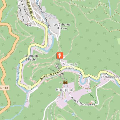
Panoramic view of the Arnette gorges from the medieval city of Hautpoul to the Croix de Prat through the Cayenne factory.
Starting from the Cathare village of Hautpoul, the historic birthplace and protector of Mazamet throughout the middle ages, this circuit climbs up and down and along the steep Arnette valley that was in the past the economic powerhouse of the region. It runs beside the small terraced gardens which used to be the pride of the inhabitants of Hautpoul. After the Cayenne factory, it crosses over to the south slopes of the Arnette and leads through meadows to the old Brettes farm and the Prat Cross. Along the route there are a number of viewpoints across the valley and towards the town, opening out onto the plain and towards the Pic de Nore (highest point in the Black Mountains). Just aside from the main circuit, by the houses of the Jamarié, there is a rocky outcrop on which the ruins of Saint Sauveur church can be explored. This was the first parish church and was used until at least the 16th century.
Technical Information
Altimetric profile
Starting point
Additional information
Updated by
Office de Tourisme de Castres-Mazamet - 07/03/2025
www.tourisme-castresmazamet.com/
Report a problem
Environments
Close to GR footpath
Overview on river
Mountain view
Forest location
Mountain location
Open period
All year round.
Contact
Phone : 05 63 61 27 07
Email : accueil@tourisme-castresmazamet.com
Topo guides and map references
Topo guides references :
Hiking sheets available at the Tourist Offices of Mazamet, Castres and Labruguière.
Sheet sold for 0,50 €.
Type of land
Rock
Stone
Ground
Not suitable for strollers
Location complements
Departure: From Mazamet, follow the D54 towards Pic de Nore and Hautpoul. From the parking lot of Hautpoul-bas.
Animals accepted
Animals are accepted.
Data author


