Hiking trail: Mont Jovet


Description
There are few mountain peaks that combine both conditions that are essential for a great experience: an exceptional viewpoint and easy access. Mont Jovet is one of these and you will have the added bonus of seeing and hearing the Tarine cows with their loud cowbells.
It all starts with the first 360° panoramic view at the top of Le Fornelet, before you set off towards the reservoir and the Prajourdan chalets. Along the way, information boards tell you the story of life in these mountain pastures in the past.
You then come to the pastures where the Tarine cows spend a happy summer: listen to the musical cacophony of the cowbells ringing!
Finally you reach Mont Jovet where you will see endless mountain peaks: La Lauzière, the Beaufortain and Vanoise massifs, Mont-Blanc and Les Ecrins. On a clear day, more dedicated mountain enthusiasts will even be able to identify the pyramid-shaped Matterhorn, the legendary mountain peak of the Swiss Valais.
After the effort comes the reward! The refuge below proposes delicious platters of cold meats and its famous omelettes, made with organic, short-circuit products!
The really lucky ones will be able to spend the night at the refuge and enjoy the best moment of the day when the sun rises over the mountain ridges: a unique experience!
***
An orientation table shows you all the surrounding mountain peaks.
Technical Information
Altimetric profile
Starting point
Points of interest

The gondola lift of Montalbert
The gondola lift of Montalbert allow you to join the summit of the Fornelet and the Prajourdan area at an altitude of 2000 metres.
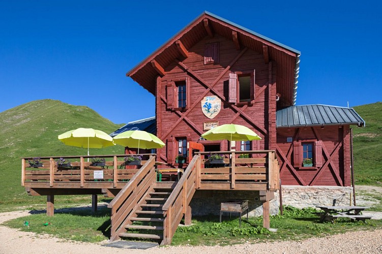
Mont Jovet mountain hut
Come and enjoy the breathtaking panorama from the recently restored Mont Jovet refuge. Guarded in summer, it is ideal for a discovery with family, friends or as a couple.
Date and time
- From 01/05/2024 to 01/11/2024
- From 01/05/2025 to 01/11/2025
Additional information
Updated by
Office de Tourisme de la Grande Plagne - 24/06/2024
www.la-plagne.com
Report a problem
Guidebook with maps/step-by-step
Start from the top of Montalbert gondola.
1/ Follow directions down to the reservoir then walk back up to the track that leads to Prajourdan alpine pastures until you are below the last chalet, at the foot of Tête du Jarset.
2/ Take the flat track to the left that goes towards the Chalet des Etroits and Pas des Brebis.
3/ At the fork with the Col du Lac, keep following signs to Pas des Brebis.
4/ You will pass in front of the Chalet des Etroits before going up to the right.
5/ When you come to the Pas des Brebis, take the path to the right that climbs towards the peak of Mont Jovet.
6/ Once you have reached the top, go back down towards the Col du Lac. You will go past Lac Bovet before reachng the Col. Take care, the descent is quite steep before you rejoin the path you took on the way out that brings you back to the top of the gondola.
There is a possible variant via Tête du Jarset and the ridges (take care on the open sections). After the last chalet at Prajourdan, take the path to the right that goes up into the forest towards Tête du Jarset. When you reach the top, you must walk along the ridge to join Col du Lac. Come back down to Lac Bovet before going back up to the top of Mont Jovet.
Open period
From 01/05 to 01/11.
Contact
Phone : 04 79 09 77 33
Email : info.montalbert@la-plagne.com
Website : www.montalbert.com
Facebook : fr-fr.facebook.com/plagnemontalbert
Data author
