Alert
Alerts
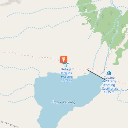
Étang d'Araing
IGN cards


Description
This lovely walk will take you down the Biros valley to admire the Etang d'Araing, nestling at the foot of the Pic du Crabère. Bordered by the GR10, the refuge overlooking it can be a stopover for discovering other natural beauties of the Biros.
Additional information:
We strongly advise against hiking the Etang d'Araing in winter (avalanche paths).
Technical Information
Altimetric profile
Starting point
Points of interest

Date and time
- From 15/04/2026 to 01/11/2026
Additional information
Updated by
Office de Tourisme Couserans Pyrénées - 26/11/2025
www.tourisme-couserans-pyrenees.com/
Report a problem
Environments
Lakeside or by stretch of water
Lake view
Mountain view
Waterside
Panoramic view
Presence of livestock and guard dogs
20 - 30 min walk to bus stop
Location complements
From the A64 motorway, take exit 20 towards Saint-Girons.
On entering Saint-Girons, turn right onto the D618.Pass Castillon en Couserans and continue as far as the village of Sentein. At the hamlet of Le Pont, turn right, then right again to the Anglade car park (please note that large vehicles cannot manoeuvre and park in the car park, so park in the hamlet of Le Pont).
Open period
From 15/04 to 01/11 daily.
Subject to favorable snow and weather conditions.
Type of land
Rock
Stone
Ground
Contact
Phone : 05 61 96 26 60
Email : contact@tourisme-couserans-pyrenees.com
Facebook : https://www.facebook.com/TourismeCouseransPyrenees/
Guidebook with maps/step-by-step
0h 815 m - The trailhead is above the reception building at the Anglade car park.
20 min. - 815 m hamlet of Fréchendech.Go straight ahead along the well-marked path alongside the stream, then it descends to the river and crosses a footbridge (880m).
1 h - Passerelle des piches (1105m alt.)
Without crossing the footbridge, continue straight ahead on the well-marked path. At around 1220m, ford a small stream. A little further on, follow the signs for the Araing pond. The path twists uphill and continues slightly downhill to the right (south-west). You will reach the end of the forest. The path rises up through the grass to quickly reach the "Cabane d'Araing".
2h 25 - Illau hut (altitude 1490m)
The path climbs to the south-east for 50 m, then crosses to the right (south). Go quickly through the woods again, then ford a small stream. The path continues to climb among the stones (south-west). A final dip takes you up to a collet, opposite the Araing pond dam. Here you will find the GR10 (red and white markings).
3h20 - Junction of the GR10 (1910m)
Take the GR10 path to the right, following the red and white markings (west). The path passes under the dam, then climbs slowly to the refuge.
Return along the same path to the hamlet of Fréchendech and the Anglade car park.
Data author
