Alert
Alerts
From the valley of Verzolet to the plateau of Hermelix


IGN cards


Description
The Verzolet valley is a haven of freshness during the summer season. Fields and pasture lands on the causse: this walking route unobtrusively nestled between the Sorgues valley and the frontal causses provides striking contrastsFrom the church, follow the D7 towards Saint-Félix-de -Sorgues 50 m,take the first left and go past the bakery. After the porch, head to the right and then climb,let the fork to right and continue to climb over 250 m after the water resevoir.Take the left path towards Hermelix. Run along the fields on 800 m,down up to the Verzolet by the operating path,on a path that sinks the woods. After 1 km, cross a ravine and continue until a gateway.Shortly after the gateway, at the fork, follow the left path that climb to Hermelix.Bypass the village on the left and take still left,explotation path about 200 m.Getting to a branch indicating towards Versols, right. Access to the fountain: to head left (southwest) and return the farm road to the intersection indicating Versols.Take the path that runs between two rows of boxwood, pass before the lavogne and continue for 1 km. Take route du Causse Hermelix 50 m left, then go to the left to arrive to the farm Sayssou.150 m before the buildings around the farm by the right. After 100 meters slightly uphill, around the bend,turn left into the path down to the ravine Sayssou.Pass before the cross Sayssou,continue the descent and lead on the explotation road.Continue, almost opposite, the path down the slope and joins Versols.
Technical Information
Altimetric profile
Starting point
Steps
Points of interest


Additional information
Public transport
Travel by bus or train: www.mobimipy.fr/carpooling : BlaBlaCar, Rézo Pouce, Covoiturage-libre, Idvroom, LaRoueVerte, Roulez malin
Advice
Box tree moths are active from May to October. During the caterpillar phase, they feed on the leaves of box trees. They crawl down trees and move on long silken threads, although these threads are annoying when hiking they do not pose any health risk
Advised parking
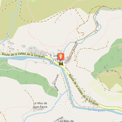
Cross the bridge and turn left on the bank opposite the village
Access
Versols, 10 km south of Saint-Affrique by D 7
Arrival
Versols
Ambiance
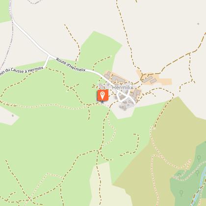
Explore the Verzolet valley and its stream which is a tributary to the Sorgues river, then walk uphill towards the Hermilix causse. There, as far as the eye can see, enjoy a landscape shaped by the agro-pastoral activity unfolding before you. The beautiful lavogne in Hermilix is worth seeing: a large pond with paved bottom and edge to water the sheep.
Departure
Versols in front of the church
Data author
