To see around
See more
Open
Close
Show
Show
Show
Show
Show
Show
Show
Show
Show
Show
Show

Oups... It would appear that Cirkwi does not have permission to use your location.

Description
Map
Steps
Points of interest
Ratings and reviews
See around

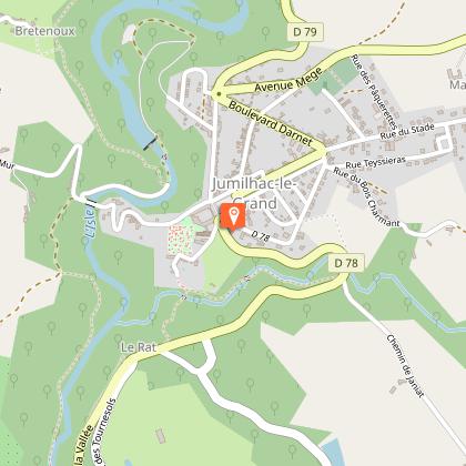
Dans la roue de Lawrence d'Arabie Etape 4 Hautefort-La Coquille

Description

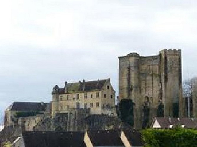
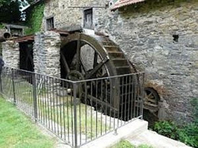
In 1908, a young English student, T E Lawrence, was fascinated by the medieval period. He decided to cycle around France on the trail of Richard the Lionheart, and this fourth stage will take him from Hautefort to La Coquille. After Hautefort, head for Cherveix Cubas and its 13th century "lantern of the dead", then continue to Excideuil and its castle. You will then arrive in the picturesque village of Preyssac d'Excideuil and the road will lead you to Payzaco where you can visit the Vaux paper mill from the early 17th century. Lawrence then continues on the Richard the Lionheart road, which he joins at Saint Yrieix la Perche. For practical reasons, we suggest a junction to La Coquille where there is a railway station, passing through Jumilhac le Grand whose castle towers inspired one of the most famous engraver, Gustave Doré.

Technical Information

Racing biking
Difficulty
Hard
Dist.
65 km
Show more

Altimetric profile

Starting point

, 24230HAUTEFORT
Lat : 45.259500006Lng : 1.149625059

Steps

image du object
1

Hautefort-Preyssac d'Excideuil

0mDépart Hospice, dir « Les 3 ponts/La Besse » D72 dir Boisseuilh 1k300Tourner à gauche dir « Mouney Bas » 2k400A gauche, dir « Leymongédie »/ »Les Vidaloux » 3k600Au carrefour, prendre à droite 4k500Tourner à gauche 5k800CHERVEIX CUBAS 6k200A gauche, D704, dir Saint Agnan 6k500D5, dir Périgueux /Tourtoirac 7k200A droite, dir « Bugeaud » 8k100Au carrefour, tout droit 10k800A droite (Laisser Saint Raphaël à gauche : village situé à 1,200km, à 288m d’altitude avec table d’orientation) 10k900A gauche, dir « Pierre Grelière » « Saint Martin » 12k900Au carrefour, suivre Excideuil 14k800Au stop, à gauche 15k000A droite D705 dir Payzac 16k100A droite sur C2, dir Preyssac d’Excideuil 16k800Au carrefour, à gauche, dir Preyssac 18k200PREYSSAC D’EXCIDEUIL

- Dordogne -
Consulter
image du object
2

Preyssac d'Excideuil-Jumilhac

18k200PREYSSAC D’EXCIDEUIL Traverser village sur route principale 19k100A gauche, passer devant imprimerie 19k400Prendre petite route en face. Traversée D704 (DANGER) 20k900Serrer à gauche 21k300Prendre à droite, suivre tout droit D4 dir Payzac 28k700Prendre à gauche D75, dir Payzac 29k800LA CHAPELLE 30k800PAYZAC 32k400Au carrefour, à droite, dir Jumilhac D80 39k200DANGER dir Jumilhac, croisement D704 39k300ANGOISSE, suivre Jumilhac D80 50k600A droite, dir Jumilhac puis D78 à droite

- Dordogne -
Consulter
image du object
3

Jumilhac-La Coquille

51k600JUMILHAC Suivre direction La Coquille sur la place 52k200 Prendre à gauche en haut de la place 52k600Sortie de Jumilhac D79, dir La Coquille 60k300SAINT PRIEST LES FOUGERES Tout droit D79 62k400 LA COQUILLE Au feu, tourner à gauche, dir Périgueux 62k700A droite vers gare SNCF 62k800 Arrivée Gare de La Coquille (Ligne Limoges/Périgueux)

- Dordogne -
Consulter

Additional information

Contact

Fixed telephone : +33 5 53 82 85 79
Debet Philippe Service du Tourisme
e-mail : p.debet@dordogne.fr
Web site (URL) : rando.cg24.fr

Balisage

Orange
panneaux

Typologie de l'itinéraire

Walking trail

Thèmes

Cultural
Historical

Data author

Image Dordogne
proposed by Dordogne
24000 France

Ratings and reviews

To see around
See more
Open
Close
Show
Show
Show
Show
Show
Show
Show
Show
Show
Show
Show
Caution!
We have no information on the difficulty of this circuit. You may encounter some surprises along the way. Before you go, please feel free to inquire more and take all necessary precautions. Have a good trip! 🌳🥾