Alert
Alerts
Type of practice
Walking
Very easy
2h
Presentation
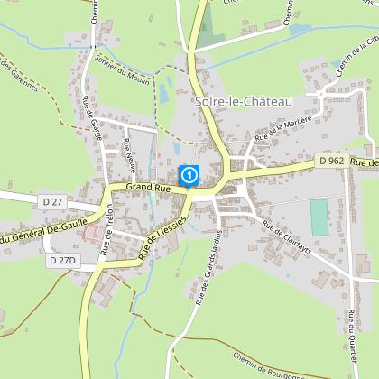
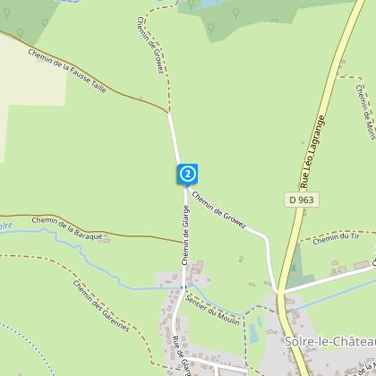
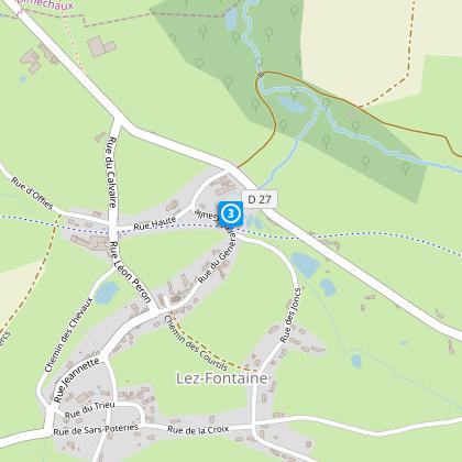
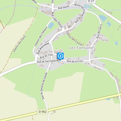
Map
Steps
Cirkwi brief's
Ratings and reviews
See around
Wood of Groez Circuit_Variant

Credit : Nord Tourisme
The Cirkwi brief
Discover the Enchanting Trails of Solre-le-Château
Created by Nord Tourisme, this captivating walk takes you through the rolling hills and hidden woodlands of the Avesnois region. Meander through charming villages adorned with quaint stone and brick houses, and come across traditional kiosks and small chapels that dot the landscape. The essence of this journey lies not just in the destination but in the tapestry of natural and architectural beauty you'll encounter. It's an invitation to step into a world where every turn is a revelation, perfectly suited for those seeking an immersive outdoor adventure amidst France's picturesque countryside.
Brief Technical Roundup
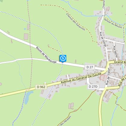
The route spans approximately 6.76 kilometers, with an elevation range between 168 meters (minimum) and 202 meters (maximum). The total positive elevation change is around 79 meters, indicating mild to moderate climbs suitable for most fitness levels. Proper footwear is advised given the terrain. Yellow markers guide the path, ensuring a straightforward navigation through the area. Note the potential for seasonal hunting activities, which may necessitate taking marked variants for safety. The crossings at RD 27 and 962 deserve extra caution due to traffic.
Seasonal Guide and Safety Tips
To ensure a delightful and safe journey through Solre-le-Château's landscapes, dress according to the season while opting for sturdy hiking shoes. Spring and autumn showcase the natural beauty at its peak, though be prepared for possible mud. Summer offers lush views, yet carry water for hydration. Winter requires caution for slippery paths. Always observe road-crossing safety at RD 27 and 962. Checking the local hunting calendar is essential to avoid the hunting seasons or adjust the path accordingly, ensuring an uninterrupted and serene experience.
Exploring the Heart of Avesnois
Solre-le-Château, nestled within the picturesque Avesnois region of Nord, France, holds a treasure trove of history and culture. This area, known for its distinctive landscapes shaped by centuries of human interaction with nature, boasts a rich tapestry of agricultural and architectural heritage. The stone and brick houses, many adorned with the unique blue stone of the region, echo the skilled craftsmanship of past generations. The village kiosks and chapels add layers of communal and spiritual significance, highlighting the area's deep-rooted cultural identity within the Hauts-de-France.
Weather Insights for Explorers
The Avesnois region, experiences a temperate climate with distinct seasons, making it a year-round destination. However, the optimal visiting period is late spring through early autumn when the weather is mild, and the natural scenery is especially vibrant. Winters are generally cold and might present challenges for less experienced hikers due to slippery paths. Always check the local weather forecast before setting out to make the most of your adventure in Solre-le-Château, ensuring a memorable experience amidst the serene beauty of Nord, France.
Created by Nord Tourisme, this captivating walk takes you through the rolling hills and hidden woodlands of the Avesnois region. Meander through charming villages adorned with quaint stone and brick houses, and come across traditional kiosks and small chapels that dot the landscape. The essence of this journey lies not just in the destination but in the tapestry of natural and architectural beauty you'll encounter. It's an invitation to step into a world where every turn is a revelation, perfectly suited for those seeking an immersive outdoor adventure amidst France's picturesque countryside.
Brief Technical Roundup
The route spans approximately 6.76 kilometers, with an elevation range between 168 meters (minimum) and 202 meters (maximum). The total positive elevation change is around 79 meters, indicating mild to moderate climbs suitable for most fitness levels. Proper footwear is advised given the terrain. Yellow markers guide the path, ensuring a straightforward navigation through the area. Note the potential for seasonal hunting activities, which may necessitate taking marked variants for safety. The crossings at RD 27 and 962 deserve extra caution due to traffic.
Seasonal Guide and Safety Tips
To ensure a delightful and safe journey through Solre-le-Château's landscapes, dress according to the season while opting for sturdy hiking shoes. Spring and autumn showcase the natural beauty at its peak, though be prepared for possible mud. Summer offers lush views, yet carry water for hydration. Winter requires caution for slippery paths. Always observe road-crossing safety at RD 27 and 962. Checking the local hunting calendar is essential to avoid the hunting seasons or adjust the path accordingly, ensuring an uninterrupted and serene experience.
Exploring the Heart of Avesnois
Solre-le-Château, nestled within the picturesque Avesnois region of Nord, France, holds a treasure trove of history and culture. This area, known for its distinctive landscapes shaped by centuries of human interaction with nature, boasts a rich tapestry of agricultural and architectural heritage. The stone and brick houses, many adorned with the unique blue stone of the region, echo the skilled craftsmanship of past generations. The village kiosks and chapels add layers of communal and spiritual significance, highlighting the area's deep-rooted cultural identity within the Hauts-de-France.
Weather Insights for Explorers
The Avesnois region, experiences a temperate climate with distinct seasons, making it a year-round destination. However, the optimal visiting period is late spring through early autumn when the weather is mild, and the natural scenery is especially vibrant. Winters are generally cold and might present challenges for less experienced hikers due to slippery paths. Always check the local weather forecast before setting out to make the most of your adventure in Solre-le-Château, ensuring a memorable experience amidst the serene beauty of Nord, France.
Automatically generated.
IGN cards

2806SB - MAUBEUGE JEUMONT
Editor : IGN
Collection : TOP 25 ET SÉRIE BLEUE
Scale : 1:25 000
13.90€

102 LILLE MAUBEUGE PNR SCARPE ESCAUT PNR DE L'AVESNOIS
Editor : IGN
Collection : TOP 100
Scale : 1:100 000
8.40€

D02-08 AISNE ARDENNES
Editor : IGN
Collection : CARTES DÉPARTEMENTALES IGN
Scale : 1:150 000
5.90€

D59-62 NORD PAS-DE-CALAIS
Editor : IGN
Collection : CARTES DÉPARTEMENTALES IGN
Scale : 1:150 000
5.90€

NR05 GRAND EST RECTO/VERSO MASSIF DES VOSGES ALSACE LORRAINE
Editor : IGN
Collection : CARTES RÉGIONALES IGN
Scale : 1:250 000
6.80€

NR04 - GRAND EST RECTO/VERSO ARDENNE CHAMPAGNE
Editor : IGN
Collection : CARTES RÉGIONALES IGN
Scale : 1:250 000
6.80€

NR01 HAUTS-DE-FRANCE
Editor : IGN
Collection : CARTES RÉGIONALES IGN
Scale : 1:250 000
6.80€

EUROPE
Editor : IGN
Collection : DÉCOUVERTE DES PAYS DU MONDE IGN
Scale : 1:2 500 000
7.00€

PAYS-BAS BELGIQUE LUXEMBOURG
Editor : IGN
Collection : DÉCOUVERTE DES PAYS DU MONDE IGN
Scale : 1:300 000
7.00€
Technical Information
Walking
Difficulty
Very easy
Duration
2h
Dist.
6.8 km
Type of practice
Walking
Very easy
2h
Show more
Altimetric profile
Starting point
Office de Tourisme / Hôtel de Ville
,
59740
SOLRE-LE-CHATEAU
Lat : 50.1743247929Lng : 4.0905136619
Steps
Data author

Ratings and reviews
To see around