Tours
Activities
Places of interest
Where to eat
Where to sleep

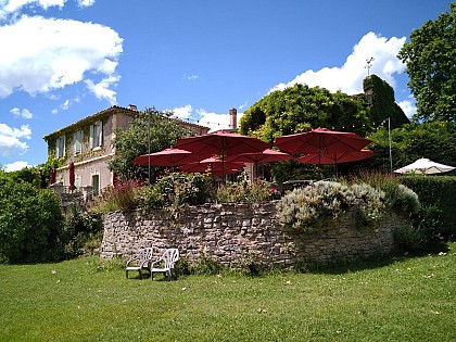
Discover A TOU VERT near Bassan, Hérault

Are you the owner?
Nestled in the charming town of Bassan in the Hérault department, the Languedoc-Roussillon region is brimming with captivating activities for nature and culture enthusiasts. Just steps from A TOU VERT, explore the natural beauty of the Haut-Languedoc Regional Natural Park, offering spectacular hiking trails and breathtaking landscapes. History buffs can delve into the local heritage with visits to...See more

Walking around A TOU VERT

See more suggestions
Family walks around A TOU VERT.
See more suggestions
The twelve bridges (Epanchoir long)
52 km

The twelve bridges (Epanchoir long)

Along the canal du Midi towards the natural reserve. Come and discover on the north, the Mount Alaric and the Corbieres , and on the South,  the Montagne Noire. Markings : yellow When facing the canal du Midi , take a right turn and follow along the canal (going South). Walk under the bridge and carry on a straight line after the last houses. You will walk near some olive trees and along the canal’s vegetation. After approximately 1.5 km, go up the bank on the right to take the path on the left right away. You end up on the old railroad (now the "chemin vert" hike) . After 200 m, at the crossroad, go on the right to immediately go up in the pine forest on the left (going West). Go up inside the pine forest, walk alongside on the right to find a small path on the left that follows the vines on the hillside with a view on La Redorte village. Follow this path until the crossroad with the paved way.  Take on the left and go up the plateau. On the way down, at the entrance of the pine forest, go on the right towards a small shadowy path quite enjoyable in the  summer. Carry on the earth path along the vines. At the crossroads, go left and down until the passage of " La Valsèque" stream (often dried up) and go back up straight forward to the neighbouring pine forest (going South). Turn on the left (going West) and walk along the pine forest. Walk in front of the square tower of La Valsèque (ancient observatory during WWII at 92m high). Go along the paved way and walk alongside La Valsèque’s smallholding by the right. Follow through the path in the vines until the Estagnol pond  (National Reserve for wild fauna).Take the paved way (going North), go along the pond until the cross-path with the tall pines. Take the path on the left then immediately on the right trough the pine forest. Go around the pond by a small path on the right that progressively goes back up the hillside to a small vineyards shack after walking at the bottom of an electric pylon. Once at the shack, take the path on the right (going East). You are now on the Estagnol plateau (100 m high). At the crossroad, go down the paved way on the left (going North-East). Leave the Laval path and go on the bridge over the Rivassel stream. Cross the RD 11 and use the path in front of you. Walk to the Argent-Double river and the « Gourgue de Granat ». Follow the river on its right (East). Then go back towards the village. We then oversee the ancient aqueduct’s archway. Take the Pic de Nore street on the left. Then turn immediately on the right on Languedoc avenue. At the crossroad, turn left on Jean Jaurès main avenue for approximately  250 m then turn on the right on the old railroad to reach the RD11. Cross it, turn left then right ( « voie romaine » street).Further down, on the right to the Port avenue then straight forward to go back to Port La Fabrique.

4 h
11 km
Very easy
Show
L'épanchoir court - Canal du Midi
52 km

L'épanchoir court - Canal du Midi

A family walk along the Canal du Midi Signs: Yellow markings Start from the Port. In front of the canal, turn left to take the passage of the tree nurseries (direction North), then cross the RD 11 and the cemetery parking lot. Climb the embankment and go along the cemetery wall (direction North). At the path, turn left and go down along the cemetery, then turn right onto a path lined with many olive trees (direction East). In front of the canal, turn left and cross the bridge over the Argent-Double river, "Le Passelis". Follow the towpath. You will pass in front of "La Dinée", currently the operation centre of the Voies Navigables de France (Navigable Waterways of France), then in front of the "Drain de La Dinée" or aqueduct, on the left, which collects by drainage the waters of the plain of Azille. Pass over the stone bridge of the Canal du Midi, on the right (direction South). Go towards the “Métairie (farmhouse) du Bois”, which is bypassed on the left. You will soon pass the old (dilapidated) lavoir of the Métairie. Then take the path on the right just before the small lake (trout fishing). Go along the Argent-Double river and cross the "Petit Bois" which is much appreciated for its shade in the summer. Cross the river on a small bridge. We arrive in front of the Epanchoir. Climb up to the Epanchoir and cross it. Pass under the bridge of the RD 11 and continue along the canal until the next bridge (road of Puichéric), turn right to cross the bridge. At the end of the bridge, turn left into a small passageway that goes down towards the port.

1 h
3.7 km
Very easy
Show
To get to Saint-Jean d'Alcas via A75 (coming from Montpellier or Clermont-Ferrand), take exit 48 towards Cornus and when reachin
53 km

To get to Saint-Jean d'Alcas via A75 (coming from Montpellier or Clermont-Ferrand), take exit 48 towards Cornus and when reachin

This getaway which is devoted to historical heritage, follows several trails and a path that is cut into the rock and leads you on the borderline of the Rougier de Camarès, an amazing patchwork of red ochre soils.From the village centre of Sylvanès take a small road (between the Town Hall and the restaurant) that leads to Maxels.In the hamlet, take the left path and ford the brook twice, walk the ascending path up to a trail intersection.Once you have ford across the brook again, take the left trail and walk around the Bataille farm to the right, the trail continues to rise. On the plateau, take the left trail that leads to the road and to the village of Gissac. Enjoy the scenic view over the Rougier de Camarès, the pic de Roste, the Merdelou and the Monts de Lacaune. Walk across the village of Gissac (castle and washing place are worth to be seen) and head towards the Montaigut castle on D105.At the exit of the village take right a bouissière that runs down towards the Moulin (formerly a fish farm). Walk across the Moulin and go for approximately 600 m up a small road.Before the hamlet of Douzou, take right a track, then at the junction of 4 trails take the one opposite which leads to the Besc hillside catchment reservoir. After the reservoir, take the left trail that gradually rises. Follow this main trail up to a hairpin bend on the right side.100 m after the hairpin bend, take to the left a recently completed pathway (be careful not to miss the trailhead). The path rises zigzagging through the woodland, crosses a 1st trail and joins a 2nd one which is to be followed on the left.Approximately 200 m after this intersection, leave the ascending path to the right and follow the contour line. The hike has already provided magnificent views over the Rougier and far in the distance, offered a first vision of the Montaigut castle. Keep walking up to a field, the logging road runs down to the left and goes along a 2nd field.You soon leave this path to take a track (cairn) which starts to the right of the field. This track crosses a trail and reaches the abandoned farmhouse of Gaujoux. After the farm, go ahead along the track that turns into a path and follows the contour line towards the Montaigut castle. Keep walking on the main path overlooking the Rougier. This path that crosses the Aigue Lebade ravine has been often hewn out of the rock.  The path goes along the plaster mill before reaching the Montaigut castle

4 h
14 km
Show
The green path - Le Chemin Vert by bike
55 km

The green path - Le Chemin Vert by bike

The old "Moux/Caunes-Minervois" railway line has been converted into a hiking trail between Puichéric and Caunes Minervois linking six villages from the plain to the foothills. It is a transverse axis that provides access to other hiking loops. Signs: Yellow and Green markings (white background) Start at the foot of the church in front of the Jardin de la Paix, where the sign indicating the “Chemin vert” line connecting Puichéric to Caunes-Minervois is located.  Take the street named "L. Pasteur" up to the roundabout in front of the town hall (former train station). Take the 5th street on the right and go past the municipal buildings to join the old railway line. Cross the iron bridge over the Canal du Midi and carry on along the paved road for about 1.5km/0.9mi and then on a tarred road to the village of La Redorte. At the entrance of the village, turn right onto the D72. Before the bridge, on the right-hand side, go down the small pedestrian crossing then go under the bridge and cross the Port de la Fabrique until you see the Chemin Vert information panel. Continue on Avenue du Port, turn right just before the iron bridge on the Roman road. At the crossroads with the D11, turn left and 30m/100ft further on turn right onto the old railway line. Then turn left on avenue Jean Jaurès, go past the community centre and continue until you reach the Place de l'Eglise. Turn right on avenue du Languedoc for about 150m/500ft and opposite the entrance to the underpass of the Château de La Redorte, turn right via the alley of plane trees and cross the Saint-Georges bridge over the river "l'Argent Double". Just after the demolished bridge, turn left to go alongside and take the old railway line. At the junction with the D72, turn right for 200m/650ft until the crossroads. Turn left for about 250m/820ft (on the left there is the old Azille train station). At the junction with the rue de la Restanque, go past the Chemin Vert information panel and continue upwards. While following the signs, at the crossroads turn left in the direction of the Place aux Herbes. Cross it, continue on rue du Commerce and immediately on the right, take rue de la Poste. Arriving on the Allées Pol Lapeyre, turn left and continue your walk on the Allées de la République until you reach the Place César Franck (famous composer). Turn right and walk down the rue du Théron and just before the demolished bridge, go up the embankment on the right to find the old railway. At the crossroads with the tarred road, continue straight ahead in the direction of the D206 and cross it. Leave the château de Floris (private estate) on the left. Cross the iron bridge over the Canet stream and enjoy this section of the trail, surrounded by pine trees and vines. At the concrete path, turn right, go up for 100m/320ft then turn left , and continue on the path until you reach the intersection with a small tarred road. The markings will take you over the small culvert to the Chapelle du Bout du Pont and the information panel of the Chemin Vert de Rieux-Minervois. Cross the bridge over the Argent-Double river, go straight ahead on rue Notre-Dame. Turn left on rue du Barry (ramparts on the left) then right up rue Saint Blaise (on the right the Saint Blaise tower). Go past the Tourist Information Center and the Sainte-Marie heptagonal church. In front of the town hall, on the left place du Général Bousquet then on the right on avenue Louis Cros D11. At the post office, go into the rue du Château and opposite the school, take the rue du Moulin towards the boulodrome (boules/pétanque sports ground). Continue straight ahead, go along the distillery and continue in the direction of the village of Peyriac-Minervois where you will find the Chemin Vert information panel at the entrance. Continue straight ahead, rue de la porte rouge and at the crossroads, turn right and go down rue des Tonneliers until you reach Place de la Libération. Continue on the borders of the river "l' Argent Double". At the crossroads, take the rue des Mauves opposite and then the chemin des Prades. Next intersection, turn left for 200m/650ft then right. At the end of the tarmac road, in the middle of the vineyards, take the dirt track on your left and leave the private estate of Pautard on your right. Arriving on an olive tree alley, turn left towards the water tower, then straight ahead and leave the hamlet Tinal d'Abrens (commune of Laure-Minervois) on your left. Continue the hike until you reach the old railway line. At the level of the culvert, take the dirt track on the right along a tree hedge. Once you have passed the recycling centre, go into the pine alley. Cross the D115 and continue straight ahead on the old railway line in the direction of Caunes-Minervois. In the trading estate, join the D115, turn left for about 300m/985ft and you will arrive at the old railway station at the end of the Chemin Vert.  

3 h
24 km
Very easy
Show
The green path - Le Chemin Vert
55 km

The green path - Le Chemin Vert

The old "Moux/Caunes-Minervois" railway line has been converted into a hiking trail between Puichéric and Caunes Minervois linking six villages from the plain to the foothills. It is a transverse axis that provides access to other hiking loops. Signs: Yellow and Green markings (white background) Start at the foot of the church in front of the Jardin de la Paix, where the sign indicating the “Chemin vert” line connecting Puichéric to Caunes-Minervois is located.  Take the street named "L. Pasteur" up to the roundabout in front of the town hall (former train station). Take the 5th street on the right and go past the municipal buildings to join the old railway line. Cross the iron bridge over the Canal du Midi and carry on along the paved road for about 1.5km/0.9mi and then on a tarred road to the village of La Redorte. At the entrance of the village, turn right onto the D72. Before the bridge, on the right-hand side, go down the small pedestrian crossing then go under the bridge and cross the Port de la Fabrique until you see the Chemin Vert information panel. Continue on Avenue du Port, turn right just before the iron bridge on the Roman road. At the crossroads with the D11, turn left and 30m/100ft further on turn right onto the old railway line. Then turn left on avenue Jean Jaurès, go past the community centre and continue until you reach the Place de l'Eglise. Turn right on avenue du Languedoc for about 150m/500ft and opposite the entrance to the underpass of the Château de La Redorte, turn right via the alley of plane trees and cross the Saint-Georges bridge over the river "l'Argent Double". Just after the demolished bridge, turn left to go alongside and take the old railway line. At the junction with the D72, turn right for 200m/650ft until the crossroads. Turn left for about 250m/820ft (on the left there is the old Azille train station). At the junction with the rue de la Restanque, go past the Chemin Vert information panel and continue upwards. While following the signs, at the crossroads turn left in the direction of the Place aux Herbes. Cross it, continue on rue du Commerce and immediately on the right, take rue de la Poste. Arriving on the Allées Pol Lapeyre, turn left and continue your walk on the Allées de la République until you reach the Place César Franck (famous composer). Turn right and walk down the rue du Théron and just before the demolished bridge, go up the embankment on the right to find the old railway. At the crossroads with the tarred road, continue straight ahead in the direction of the D206 and cross it. Leave the château de Floris (private estate) on the left. Cross the iron bridge over the Canet stream and enjoy this section of the trail, surrounded by pine trees and vines. At the concrete path, turn right, go up for 100m/320ft then turn left , and continue on the path until you reach the intersection with a small tarred road. The markings will take you over the small culvert to the Chapelle du Bout du Pont and the information panel of the Chemin Vert de Rieux-Minervois. Cross the bridge over the Argent-Double river, go straight ahead on rue Notre-Dame. Turn left on rue du Barry (ramparts on the left) then right up rue Saint Blaise (on the right the Saint Blaise tower). Go past the Tourist Information Center and the Sainte-Marie heptagonal church. In front of the town hall, on the left place du Général Bousquet then on the right on avenue Louis Cros D11. At the post office, go into the rue du Château and opposite the school, take the rue du Moulin towards the boulodrome (boules/pétanque sports ground). Continue straight ahead, go along the distillery and continue in the direction of the village of Peyriac-Minervois where you will find the Chemin Vert information panel at the entrance. Continue straight ahead, rue de la porte rouge and at the crossroads, turn right and go down rue des Tonneliers until you reach Place de la Libération. Continue on the borders of the river "l' Argent Double". At the crossroads, take the rue des Mauves opposite and then the chemin des Prades. Next intersection, turn left for 200m/650ft then right. At the end of the tarmac road, in the middle of the vineyards, take the dirt track on your left and leave the private estate of Pautard on your right. Arriving on an olive tree alley, turn left towards the water tower, then straight ahead and leave the hamlet Tinal d'Abrens (commune of Laure-Minervois) on your left. Continue the hike until you reach the old railway line. At the level of the culvert, take the dirt track on the right along a tree hedge. Once you have passed the recycling centre, go into the pine alley. Cross the D115 and continue straight ahead on the old railway line in the direction of Caunes-Minervois. In the trading estate, join the D115, turn left for about 300m/985ft and you will arrive at the old railway station at the end of the Chemin Vert.

5 h
24 km
Very easy
Show
The green path - Le Chemin Vert by horse
55 km

The green path - Le Chemin Vert by horse

The old "Moux/Caunes-Minervois" railway line has been converted into a hiking trail between Puichéric and Caunes Minervois linking six villages from the plain to the foothills. It is a transverse axis that provides access to other hiking loops. Signs: Yellow and Green markings (white background) Start at the foot of the church in front of the Jardin de la Paix, where the sign indicating the “Chemin vert” line connecting Puichéric to Caunes-Minervois is located.  Take the street named "L. Pasteur" up to the roundabout in front of the town hall (former train station). Take the 5th street on the right and go past the municipal buildings to join the old railway line. Cross the iron bridge over the Canal du Midi and carry on along the paved road for about 1.5km/0.9mi and then on a tarred road to the village of La Redorte. At the entrance of the village, turn right onto the D72. Before the bridge, on the right-hand side, go down the small pedestrian crossing then go under the bridge and cross the Port de la Fabrique until you see the Chemin Vert information panel. Continue on Avenue du Port, turn right just before the iron bridge on the Roman road. At the crossroads with the D11, turn left and 30m/100ft further on turn right onto the old railway line. Then turn left on avenue Jean Jaurès, go past the community centre and continue until you reach the Place de l'Eglise. Turn right on avenue du Languedoc for about 150m/500ft and opposite the entrance to the underpass of the Château de La Redorte, turn right via the alley of plane trees and cross the Saint-Georges bridge over the river "l'Argent Double". Just after the demolished bridge, turn left to go alongside and take the old railway line. At the junction with the D72, turn right for 200m/650ft until the crossroads. Turn left for about 250m/820ft (on the left there is the old Azille train station). At the junction with the rue de la Restanque, go past the Chemin Vert information panel and continue upwards. While following the signs, at the crossroads turn left in the direction of the Place aux Herbes. Cross it, continue on rue du Commerce and immediately on the right, take rue de la Poste. Arriving on the Allées Pol Lapeyre, turn left and continue your walk on the Allées de la République until you reach the Place César Franck (famous composer). Turn right and walk down the rue du Théron and just before the demolished bridge, go up the embankment on the right to find the old railway. At the crossroads with the tarred road, continue straight ahead in the direction of the D206 and cross it. Leave the château de Floris (private estate) on the left. Cross the iron bridge over the Canet stream and enjoy this section of the trail, surrounded by pine trees and vines. At the concrete path, turn right, go up for 100m/320ft then turn left , and continue on the path until you reach the intersection with a small tarred road. The markings will take you over the small culvert to the Chapelle du Bout du Pont and the information panel of the Chemin Vert de Rieux-Minervois. Cross the bridge over the Argent-Double river, go straight ahead on rue Notre-Dame. Turn left on rue du Barry (ramparts on the left) then right up rue Saint Blaise (on the right the Saint Blaise tower). Go past the Tourist Information Center and the Sainte-Marie heptagonal church. In front of the town hall, on the left place du Général Bousquet then on the right on avenue Louis Cros D11. At the post office, go into the rue du Château and opposite the school, take the rue du Moulin towards the boulodrome (boules/pétanque sports ground). Continue straight ahead, go along the distillery and continue in the direction of the village of Peyriac-Minervois where you will find the Chemin Vert information panel at the entrance. Continue straight ahead, rue de la porte rouge and at the crossroads, turn right and go down rue des Tonneliers until you reach Place de la Libération. Continue on the borders of the river "l' Argent Double". At the crossroads, take the rue des Mauves opposite and then the chemin des Prades. Next intersection, turn left for 200m/650ft then right. At the end of the tarmac road, in the middle of the vineyards, take the dirt track on your left and leave the private estate of Pautard on your right. Arriving on an olive tree alley, turn left towards the water tower, then straight ahead and leave the hamlet Tinal d'Abrens (commune of Laure-Minervois) on your left. Continue the hike until you reach the old railway line. At the level of the culvert, take the dirt track on the right along a tree hedge. Once you have passed the recycling centre, go into the pine alley. Cross the D115 and continue straight ahead on the old railway line in the direction of Caunes-Minervois. In the trading estate, join the D115, turn left for about 300m/985ft and you will arrive at the old railway station at the end of the Chemin Vert.

4 h
24 km
Very easy
Show

What to do in A TOU VERT

See more suggestions
Find the best activities in A TOU VERT and book easily online.
See more suggestions
Montpellier pass: visits, activities, museums and transport included
55 km

Montpellier pass: visits, activities, museums and transport included

Discover Montpellier thanks to the City Pass! The convenient, highly recommendable Montpellier City Pass lets you visit anything you want during 24, 48 or 72 hours. It includes admission to museums and attractions of the region. It also offers unlimited access to public transport! Thanks to the Montpellier Pass, experience all the ferment of the city in one single offer! Find out about all of Montpellier's secrets! You will have free access to the following museums, tours and sites for the selected period of time (24, 48 or 72 hours): * Guided Montpellier tour to discover the best of the historic city centre and its hidden spots... * Montpellier old town museum * Pharmacy and Chapelle de la Miséricorde * Gardens of the Flaugergues castle * Amazonian greenhouse and zoological gardens in Lunaret * A game of bowling in Montpellier In addition, this pass will give you many discounts on: the aquarium, the tourist train, souvenir shops, wine, chocolate... But also on amusement and adventure parks around Montpellier, the network of history and archaeology museums and many other museums in the Montpellier region. CLICK HERE [/"http://www.ot-montpellier.fr/_objets/medias/autres/city-card-2015-175.pdf"] to see all free services and discounts included in the Montpellier Pass Finally, you will have unlimited access to public transport (buses, tram) during the selected period. Choose the Montpellier pass for the duration of your choice and make the most of your stay in Montpellier!

Allée Jean de Lattre de Tassigny 34000 Montpellier
Book from 15 EURBook
Show
Via Ferrata in Mazamet
71 km

Via Ferrata in Mazamet

Looking for big thrills? Desire to surpass yourself? The via ferrata of Mazamet is for you! In the the Arnette gorges, in Mazame, via ferrata and giant zip line, under the footbridge. Acrobats and adventurers will enjoy this safe activity which completes, since 2022 the current tourist offer. This land is located in a protected natural site carried by an outstanding historic heritage (Cormouls-Houlès remarkabe gardens, St-Sauveur ruins, classified archeological site), and a rich and diverse wildlife. Nearby, after crossing the Mazamet's Hymalayan footbridge at 70 meters high over the Arnette river, you will find the medieval village of Hautpoul and its gardens, as well as, on the GR7, the House of Wood and Toy, its arboretum and its orchard. A nice wander along the 'Art Net' to picnic in th the shadows of chestnut trees. - Via Ferrata with ziplines : . Access: 20 mn . Drop : 90 m . Length: 880 ml . Difficulty: AD à D+ . Duration: 2 h 30 . Way back: 20 mn - Via Ferrata without zipline . Access: 30 mn . Drop: 110 m . Length: 370 ml . Difficulty: AD à D+ . Duration: 1 h 30 . Way back: 20 mn - Via Ferrata (upper part of Hautpoul) . Access: 20 mn . Drop: 60 m . Length: 130 ml . Difficulty: PD . Duration: 45 mn . Way back: 25 mn Minimum gear required: . Helmet . Harness . Closed shoes . Rest Karabiner & short lanyard . 2 wide aperture autoblock gate karabiners . Karabiner aerolink specifically for continuous safe line . Lanyard aeroline Ferrata . Double lanyard with shock absorber . Gloves General recommendations: Access to the Via Ferrata of Mazamet is prohibited: - to children measuring less than 1,35m and minors who are not accompanied by un experienced adult ; - outside opening hours and over night ; - in adverse weather conditions and especially when the route is slipppery and affected by snow, ice and stormy conditions. You agree to undertake this activity at your own risk. If you have little or no experience in this type of activity, please contact the services of a guide. Equipment rental: Mazamet Tourist Office Online booking: https://www.tourisme-castresmazamet.com/billetterie Rates: 18€/pers. Groups more than 5 persons: 16,50€/pers. Groups more than 10 persons : 15€/pers. Deposit: 400€ (on the day of the rental, chèque ou Crédit card) For beginners or persons needing a guide, you can contact: - Aude Escapades - Laurence Combes 06 03 50 00 85 - Axecime - Yannick Saulnier 06 08 42 27 13

95 rue de la Resse 81200 Mazamet
Book from 0 €Book
Show

What to visit in A TOU VERT

See more suggestions
Admire the unique architecture of A TOU VERT.
See more suggestions
Navacelles circus
58 km

Navacelles circus

In the arid Causses of Larzac to the north and Blandas to the south, the river Vis has carved out an impressive green furrow, dominated at its heart by a hill. This is the Cirque de Navacelles, a geological curiosity shaped by 600,000 years of patient labor. Straddling the departments of Gard and Hérault, the Vis river has carved out its bed in the limestone of the southern causses (Blandas and Larzac), forming vast meanders. Over time, erosion of the rock has enabled the river to cut its course as short as possible, abandoning its former bed. Thus was born the Cirque de Navacelles. To discover it in its entirety, don't miss the 300m-deep descent to the bottom of the cirque. Here, in a green oasis on the banks of the Vis waterfall, lies the village of Navacelles. A botanical trail, accessible to all, has been laid out here. Today, the cirque de Navacelles is a member of the Grands Sites de France, and boasts over 250,000 visitors a year. Since 2011, it has been nestled in the heart of a UNESCO World Heritage Site (Causse & Cévennes). The heritage of the Cirque de Navacelles Grand Site The joint work of man and nature, the former has used all its power to sculpt the material and shape the site's geological outlines, while the latter has patiently created the "finishing touches": built islands, roads, bridges and paths, low walls supporting the terraces, all at the cost of laborious work to shape the relief. The Cirque de Navacelles Grand Site boasts a magnificent heritage of archaeology, geomorphology and agropastoralism. Hiking and outdoor activities The Grand Site du Cirque de Navacelles is a territory where nature and heritage reveal themselves to those who take the time to observe, listen and smell... Free walks are a wonderful way to discover the fauna and flora, as well as the heritage: lavognes, pastoral enclosures, old bread ovens... Reference books are available to help you discover them (cartoguide, rando-fiche...). THE BELVEDERES OF BLANDAS Situated just 3 minutes from the village of Blandas, the belvederes offer three breathtaking viewpoints over the Cirque de Navacelles and the Vis gorges. The Maison de Site houses a tourist documentation area, a permanent exhibition on agropastoralism, a film showing archaeological discoveries made on the Causse and in the Cirque de Navacelles, a local produce store and a restaurant serving local produce. The facilities are accessible to the disabled. Since July 2013, the "Chênes", "Doline" and "Cascade" lookouts on the Causse de Blandas offer visitors an overview of the grandiose geomorphology of the Cirque de Navacelles and establish a respectful dialogue between Man and Earth. Site accessible to four types of disability.

Belvédères de Blandas 30770 Blandas
Show

Where to eat in A TOU VERT

See more suggestions
A wide selection of restaurants awaits you in A TOU VERT.
See more suggestions

Where to sleep in A TOU VERT

See more suggestions
Discover available accommodations around A TOU VERT.
See more suggestions
Gîte pèlerins Bouisset Lasfaillades - St Jacques - Tarn
64 km

Gîte pèlerins Bouisset Lasfaillades - St Jacques - Tarn

Comfortable accommodation in the heart of a typical hamlet in Bouisset Lasfaillades, between Anglès and Castres in the Tarn. Stopover or holiday gite located between Sidobre, Monts de Lacaune and Montagne Noire, less than 300 metres from the GR 653 Way of St James. In Bouisset Lasfaillades, between Anglès and Castres in the Tarn. Our St Jacques gite is located in a charming and peaceful little hamlet in an unspoilt natural setting at an altitude of 700 metres. Set in undulating countryside between Sidobre, Monts de Lacaune and Montagne Noire, this gîte will give you the chance to relax away from the noise and bustle of the city. The village of Lasfaillades, crossed by the GR 653 Pilgrim's Way to Santiago de Compostela, offers great walking and mountain-biking opportunities just a few kilometres away. Nearby, you can also take advantage of the small lake and picnic area less than 300m away. Self-contained gîte (sleeps 8/9), located in the centre of the hamlet less than 300 metres from the GR. Ground floor entrance with terrace and garden furniture. Ground floor: fitted kitchen with large dining table, toilet and shower room, lounge with seating area, laundry room with washing machine and tumble dryer. First floor: 3 bedrooms (3 single beds), (2 single beds), (1 double bed + 1 single bed), shower room and WC. The gite also has a garage. Television and small library available. Grassed area, car park and barbecue are also available next to the gîte. Pilgrim gite with half-board available on reservation.

Bouisset 81260 Lasfaillades
Show
Caution!
We have no information on the difficulty of this circuit. You may encounter some surprises along the way. Before you go, please feel free to inquire more and take all necessary precautions. Have a good trip! 🌳🥾