Alert

Alerts

To see around
See more
Open
Close
Show
Show
Show
Show
Show
Show
Show
Show
Show
Show
Show

Oups... It would appear that Cirkwi does not have permission to use your location.

Presentation
Description
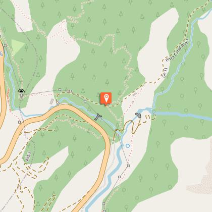
Map
Steps
Points of interest
Ratings and reviews
See around

Du Somport à Jaca

Du Somport à Jaca
Ambiance soirée bivouac Aspe rando 2011 © P Gaillard (1)
Chemins de St Jacques panneau GR653  © Francine Magrou
Chemins de St Jacques panneau Voie d'Arles © Francine Magrou

Description

In Jaca, the crossing of the Pyrenees ends. The path that leads there leaves you free to appreciate the changes that accompany this long descent southwards. From the high beech woods with their fresh and humid scents to the wheat fields crossed by arid paths lined with dry stones, in the aromas of pine and rosemary. From the quiet summer pastures, ideal for contemplation, to the lively streets of the Aragonese villages, where people are happy to call out to one another.

Technical Information

Walking
Difficulty
Hard
Duration
7h30mn
Dist.
32 km
Show more

Altimetric profile

Starting point

, 64490   URDOS
Lat : 42.872793Lng : -0.555275

Steps

Additional information

Balisage

White and red (GR®)

Typologie de l'itinéraire

Walking trail
Hiking Route (GR®)

Thèmes

Natural

Data author

12 place Jaca 64400 Oloron-Sainte-Marie Cedex France

Ratings and reviews

To see around
See more
Open
Close
Show
Show
Show
Show
Show
Show
Show
Show
Show
Show
Show
Caution!
We have no information on the difficulty of this circuit. You may encounter some surprises along the way. Before you go, please feel free to inquire more and take all necessary precautions. Have a good trip! 🌳🥾