Tours
Activities
Places of interest
Where to eat
Where to sleep

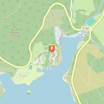
Explore Saint-marc-a-loubaud, Creuse, Limousin

Are you in charge of the destination?
Nestled in the heart of Creuse, within the picturesque Limousin region, Saint-marc-a-loubaud offers an authentic escape for nature lovers and those seeking tranquility. Surrounded by rolling hills and wooded landscapes, this charming town opens up to a variety of activities for visitors seeking adventure or relaxation.

Begin your exploration through the numerous hiking trails winding around t...
See more

Walking around Saint-marc-a-loubaud

See more suggestions
Discover the trails of Saint-marc-a-loubaud.
See more suggestions
Discovery trail of the moors and peat bogs of Mazure: Large Loop
5.8 km

Discovery trail of the moors and peat bogs of Mazure: Large Loop

Come and explore a large peat bog classified as a Natura 2000 site, rich in a remarkable heritage that is preserved.From the car park, head towards the footbridge over the stream, pass the barrier and follow the wide track to the next intersection.Turn right, go through the woods up to a viewpoint with a bench. Continue a little in the woods, then go down towards the river to the ruins of a mill.Follow the old headrace to the footbridges that allow the stream to be crossed.Take the duckboards and continue straight on the path for a good distance.At the intersection, take the left-hand path, which then branches off to the left at a footbridge and passes over the dike of an old pond.Cross the river again and remember to close the gate. Climb the steep path that goes off to the right to reach a panoramic view.Descend onto the heath to a turtle-shaped rocky outcrop.Just past this rock, there are two options. The one presented here is the option of the large loop (another sheet presents a smaller loop: "Discovery trail of the moors and peat bogs of Mazure n°22: Small loop"). Take the path that goes straight down and then goes up towards the rocky outcrop that offers a beautiful view.Go down to the bottom of the valley. Once you reach the peat bog, the path branches off to the right. The landscaping allows you to cross the wettest areas and reach a stone bridge (known as a "plank bridge").Cross the river, turn left to reach a coniferous forest.Continue straight through this forest for a long distance until you reach the intersection of four paths.Turn left, go through the woods and then continue alongside the peat bog on a path lined with old low walls.At the intersection with another trail, continue straight ahead until you reach some duckboards, then a small stone bridge that allows you to cross the river again.Just after a small round trip to the right you can explore the remains of mills. Turn left, continue straight on a path that runs along the edge of the peat bog near the heather moors.A large duckboard allows you to cross a very wet area (caution). The path continues straight ahead on the edge and then branches off to the right into a shrubby area and climbs up into a fenced meadow.A fenced corridor makes it possible to cross this meadow in complete safety (beware, however, of apiary). At the end of the meadow, take the path opposite (slightly to the left) in a coniferous forest.The path then continues through a leafy forest, branching off to the right to an old fishery.Continue on the right, following the watercourse, until the next intersection with a wide path.Take this path on the left, go on alongside the fenced pasture and continue straight on the path (taken on the outward journey) to return to the car park.

3 h
7.1 km
Very easy
Show
The devil's gully discovery trail
5.8 km

The devil's gully discovery trail

Come and discover the secrets of the legendary Devil's Rock and the unspoilt nature of the Thaurion; flowing and cascading here into a huge "gully".From the car park, go towards the road by taking the track leading to the car park. Cross it and take the small staircase that leads down the slope.Turn left and follow the course of the Thaurion. After crossing the damp ground, the path climbs upwards, turning to the left.At the top, turn right, leave the stone staircase (with metal railings) that goes down to the left. Take care, awkward passage. Slip straight between the rocks to go down to the viewpoint overlooking the valley (secured by a guardrail). Once you have enjoyed the panorama, turn around, go up to the top of the staircase you left previously and take it.At the bottom of the stairs, on the left, continue following the river and, after trying to see the hidden waterfall, go up to the left to observe a huge rocky outcrop, then return to the river.Go along the riverbank to a waterfall; the path goes up on the left to bypass a rocky outcrop, then goes down again (watch out for slips).Slip between the rocks and follow the bank until the next waterfall.Go down the metal staircase and take the footbridge. Take a break before leaving the river and take the wide path that climbs (very steep) to the road.Cross the road at the small stone staircase in the embankment opposite. Climb these few steps and then turn right diagonally to cross the abandoned road and head towards the road opposite.Take the path that runs along the road in the woods until you reach the top of a wooden staircase.The tarmac track climbs on the left and thus begins the return to the car park. Follow this wide track that crosses meadows and then enters a large coniferous forest.Continue straight on this track through the communal forest until you reach the foot of the Devil's Rock and the car park.

1 h
2.9 km
Very easy
Show
Circuit of Pallier
7 km

Circuit of Pallier

At the foot of the highest peaks of the Millevaches plateau, explore the small village of Pallier.From the Place de la Mairie-école in Gentioux-Pigerolles, turn left by the town hall onto the grassy path that climbs to the edge of the woods. Follow it until you reach an intersection.Continue to the left in the woods, go past two intersections and reach, after a few hundred metres, a crossroads.Take the track on the left and leave the grassy path on the right. Follow it for 2 km. About 200 m after the high-voltage power line, you reach an intersection.Leave the gravel track and follow the path opposite until you find a granite marker on the left.Then turn right: the path climbs slightly upwards to a tarmac-surfaced crossroads. Cross it and continue opposite by the path that goes down to Pallier for 1km. Keep straight on, through woods and meadows, to a crossroads.Take the path on the left to reach the picturesque hamlet of Pallier.In the village, visit the 12th-century chapel. Behind this building are a 16th-century Cross of Calvary fleuronnée, a 19th-century shoeing crush, the notary's house and other village houses. Return to point 6 by the same path.Turn left onto the path bordered by a low wall: it climbs through the pastures before reaching the D8 (watch out for traffic).Take the D8 on the left for 250 m, leaving the D35 on your left, then turn right onto a path that goes downwards. Pass under a high voltage line and reach a crossroads.Leave the path on the right that leads to the quarry, and take the trail on the left that runs alongside the woods and the stream. Pass to the left of a house on a wide road and join the D16 which leads to La Lézioux.Leave on your left the flowered 16th century Cross of Calvary fleuronnée, and take the first path on the right. Go straight up, all the way to the top, granite cross on the right, then go down the long path through the forest until you reach the D8.Follow the D8 on the left until you reach Gentioux-Pigerolles, where the cemetery houses tombs carved by Jean Cacaud.

3 h
9.4 km
Very easy
Show

What to do in Saint-marc-a-loubaud

See more suggestions
Plan your leisure time in Saint-marc-a-loubaud by booking activities that suit your preferences.
See more suggestions

What to visit in Saint-marc-a-loubaud

See more suggestions
Relax in the parks of Saint-marc-a-loubaud.
See more suggestions

Where to eat in Saint-marc-a-loubaud

See more suggestions
Chefs in Saint-marc-a-loubaud will delight you.
See more suggestions

Where to sleep in Saint-marc-a-loubaud

See more suggestions
Explore lodging possibilities in Saint-marc-a-loubaud.
See more suggestions
Caution!
We have no information on the difficulty of this circuit. You may encounter some surprises along the way. Before you go, please feel free to inquire more and take all necessary precautions. Have a good trip! 🌳🥾